Packhorse History of Miterdale

The valley of the River Mite in the Lake District of England is said to have three sections, each with its own distinct character. The lower portion runs through fields on its way to Ravenglass harbor, with Muncaster Fell on its southern side. The middle section is a woodland river, with more grade and faster water. In its highest reach, the river is a mountain stream running through a narrow valley. All three sections of Miterdale were historically traversed by important packhorse tracks. The packhorse era is generally considered to have been from the 12th to the late 18th century, though in some places packponies were used into the very early 20th century, and there is evidence that the Romans used packhorses during their stay in northern England from 100AD.

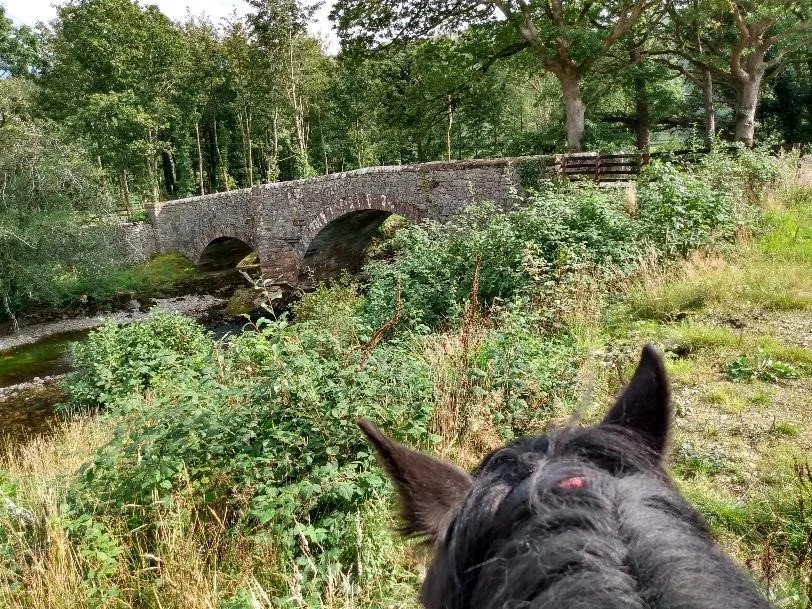
The middle reach of the River Mite in Miterdale in the Lake District. Courtesy Dr. Phil Brown

I was recently corresponding with someone in the UK who didn’t know that the Fell Pony is the native pony of northwest England, including the Lake District. Even if people do know about Fell Ponies, they often don’t know how ancestors of today’s ponies contributed to the early industrial activities of the region as pack animals. While packhorse bridges are often recognized as historic and picturesque parts of the region, the many other features that harken back to the packhorse era, including the ponies themselves, are not given equal recognition.

Wordsworth's view of the features of the Lake District as spokes of a wheel radiating from the hub (red dot) at ScaFell. Our progress documenting the packhorse history of the region is hatched in green.

Previously, we have looked at the packhorse history of the valley of the River Esk, to the south east of Miterdale. The two valleys are connected by a low rise at Eskdale Green. Other areas that we have explored in this series on packhorse history are shown on the map at right that illustrates the poet William Wordsworth’s wheel of lakes in the Lake District, with the hub as a red dot not far from the top of Miterdale.

The map of Miterdale below shows many of the features there that are related to the era of packhorses. For more detail about the general association of these features with packhorse history, see the beginning of the previous article on Eskdale (click here.)

While ‘packhorses’ is the usual term, history says they were ponies by stature since they were usually less than 14hh. Stout but shorter equines made it easier to lift the loads onto the pack saddles. Some of the packhorses in use during the peak of the packhorse era were imported: jaegers or jaggers from Germany for instance. But some were also locally reared and therefore ancestral to today’s Fell Ponies, the breed that calls the region home today.

We will begin our exploration of Miterdale at the head of the valley. It appears on the map, and many people assume, that the River Mite has its source in Burnmoor Tarn. Having walked there in 2015 with pack ponies, it is easy for me to see both the confusion and the truth. It turns out that there is a slight rise on Burnmoor that separates the Mite drainage from that of the River Esk, whose tributary Whillan Beck drains the tarn.

Burnmoor Tarn looking toward the head of Miterdale in 2015 on our packhorse day trip. It’s easy to see where ‘the Highway’ came up onto the moor. We and our pack ponies went off to the left, down along Whillan Beck towards Eskdale.

One website acknowledges the confusion and describes the truth this way, “The top of the Mite is rather unusual. Looking down on the area from above, it looks as if Burnmoor Tarn must drain into the Mite, but a slight rise in ground level means that the tarn actually feeds Whillan Beck. Instead the Mite rises in a rocky glen, a wide point in the valley surrounded by low crags on all sides with waterfalls dropping down in several places.” (1)

A packhorse track labelled ‘The Highway’ is shown on the map as a green line paralleling the headwaters of the river. Mary Fair, the noted local historian and archaeologist of neighboring Eskdale wrote more than once about the Highway. In her circa 1921 article “Some Notes on the Eskdale Twenty-Four Book” in the Transactions of the Cumberland and Westmorland Antiquarian and Archaeological Society (Transactions), Fair wrote, “According to an old landowner still living in Eskdale [the Highway] means the ancient pack-horse track (now almost lost in places), up Miterdale over Tongue Moor and into Wasdale.” (2)

At the head of the Highway, at Burnmoor Tarn, a fishery is indicated on the map. In David Bradbury’s booklet The Mighty Mite: Water Power around Eskdale and Miterdale, Cumbria, the author says that the fishery at Burnmoor Tarn was valued back into the Middle Ages. (3) Numerous references say that pack ponies were used to carry fish prior to the availability of other forms of transport, so it is possible that the Highway might have been traversed by pack ponies to move fish from Burnmoor Tarn to market towns. (4)

Coming down the Mite on the Highway, at the confluence of two river branches, an inn and a bridge are shown on the map. Robert Gambles, in his book The Story of the Lakeland Dales, says there were six farmsteads in upper Miterdale, with the earliest records of them dating from 1294. Their names included Bakerstead, Browyeat, Sword House, Miterdale Head, and Low Place. (5) The historic Nanny Horns Inn was at Sword House.

When Bob Orrell and his pair of Fell Ponies went on their Saddle Tramp in the Lake District in the 1980s, Bob chose to extend their trip slightly and go up Miterdale from Eskdale Green. At Bakerstead Farm, he met an elderly woman out walking who admired his ponies. She then told Bob a story about the Highway. “Eeh, Grandfather used to tell a tale or two about when they used to take stuff about on pack-ponies. In them days there were no roads like there is now and he, and his father, had to take their wool over the fells to Keswick. There’s a place up Miterdale called ‘the Highway’ but he used to frighten me sister and me to death with a tale about a murder at a farm up there. Every year I come back on holiday, but I’ve never plucked up courage to go and see the spot yet.” (6)

I understand the woman’s lack of nerve. I found the ghost story on the internet, and I wish I hadn’t read it, as I have far too vivid an imagination. Should you wish to read it, though, click here and scroll down to the recounting of the Beckside Boggle at Miterdale Head. Even Bob Orrell was unnerved by the story: “Having listened to the old lady’s gruesome story I was glad to leave the dark shade of the hedge and return to the heat of the sun. I half expected her to vanish into the air, pulling the hood of a cloak over her head, but instead she trotted merrily down the road…” (7)

Paul Hindle’s book Roads and Tracks of the Lake District is considered a reliable source when studying roads, tracks and bridges in the Lake District. In his discussion of packhorse bridges, a map illustration shows four bridges in upper Miterdale. (8) The Detailed Old Map 1888-1913 that I have referenced repeatedly in this series about packhorse history shows five bridges. (9) Through the wonders of the internet, I have been able to see photographs of them and place them on the map. Today some are foot bridges and one appears to carry a road, possibly accessing a quarry.

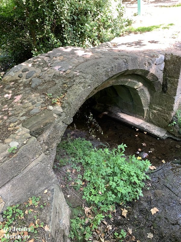
Packhorse bridge giving access to the ruins of Miterdale Head Farm. Courtesy Maggie B. Dickinson and copyright Maureen Fleming

The first bridge encountered on the map as we descend Miterdale accesses the ruins of Miterdale Head Farm and Sword House. It is often photographed and is called a packhorse bridge; it is shown here courtesy my colleague Maggie B. Dickinson and her friend Maureen Fleming. The second bridge near it on the map is currently a footbridge that accesses what was once Bakerstead Farm and has more recently been an Outward Bound School. This bridge is also labeled a footbridge on the Detailed Old Map. It is possible that at one time there may have been a packhorse bridge at this location, based on where modern tracks lie, suggesting where the Highway once ran.

The inn shown on the map at the confluence of the two river branches in upper Miterdale is referred to as Nanny Horns, as already mentioned. Some historians have not found evidence of it on the ground and consider it a storytelling device from the 19th century (10). On the other hand, Nanny Horns Inn is included on the 1923 list of Ancient Monuments in Irton township and is labeled there as being on a packhorse route. (11) The very comprehensive Lakes Guides website and Old Cumbria Gazetteer, compiled by Jean and the late Martin Norgate, include close-ups from numerous historic maps clearly showing an inn in upper Miterdale as early as 1579. (12) Maps more recent than 1695 do not consistently show this inn, explaining perhaps why there is confusion.

Gambles in The Story of the Lakeland Dales very definitively says that the Nanny Horns was at Sword House. “The ruins of Sword House have been identified as those of the former Nanny Horns Inn, once a hostelry on the major communications route between Keswick and Ravenglass, a route known to all as The Highway, a tough, hard road along which sturdy packponies carried wad [pencil lead], wool and slate to the quaysides at Ravenglass and brought sugar, rum, salt and tobacco on their return…. For all these travelers and packhorsemen the Nanny Horns meant warmth, rest and refreshment after the long and often arduous trail from Wasdale Head over the bleak moors below Scafell. We may safely assume that the inn and, no doubt, the other farmsteads hereabouts did a thriving business providing food and shelter for both man and beast. (13)

Coming further down the river, we see two pitsteads on the map across from Low Place. Mary Fair wrote in her Transactions article about early iron smelting sites called bloomeries: “There are numerous pitsteads for charcoal burning in the wood opposite Low Place, though careful search has revealed no bloomery site here.” (14) Pitsteads were used for creating charcoal, and if the pitsteads were in operation during the pack horse era, pack ponies would have been used to bring wood to the pitstead and charcoal away from the pitstead to the nearby bloomeries.

The bridge shown near these pitsteads on the map is currently a footbridge and is also labeled as such on the Detailed Old Map. Given the tracks on the Detailed Old Map, though, it seems likely that the Highway crossed the river here, suggesting that a packhorse bridge may once have existed at this location.

Two bloomery sites and two more pitsteads are shown slightly further down the river. About these features, Mary Fair wrote in her Transactions paper: “On the ancient road leading from the Whitehaven road to Low Place through Porterthwaite wood, there is the site of a small bloomery on the east bank of a little stream to the north of the road… and two charcoal pitsteads adjoining…. A quarter of a mile east …along the old road, beyond the gate, about 40 yards south of the road at the edge of a hollow at the bottom of which runs a little stream, is a bloomery site.” (15) Her ’ancient road’ is the lower end of the historic packhorse track, The Highway.

Another bridge further downstream appears in photographs to be a modern vehicle bridge, possibly to access a quarry on the north side of the river. It is labeled a footbridge on the Detailed Old Map, but like the one above it crossing the river on the map, its location suggests a packhorse bridge may have existed at this location previously.

Bridge over the River Mite at the north end of historic Smithybrow Lane.
Copyright Peter Trimming and used via Creative Commons license 2.0

Coming down the river on the map, when we reach Low Holme, the historic Smithybrow Lane comes in from Eskdale Green. Mary Fair referenced Smithy Brow in her Transactions article “Packhorse Days in Eskdale.” The lane connects Eskdale Green with the track to Strands and Whitehaven. A blacksmith shop was also in this area, hence the name of the Lane. Where the track crosses the River Mite, there are numerous features with packhorse connections. A bridge is shown on the map and in the photo above. With its low parapets and on a known packhorse route, it deserves to be investigated as a possible historic packhorse bridge since such a bridge certainly existed at the location during the packhorse era.

A mill is also shown. David Bradbury, in his booklet The Mighty Mite, says that a carding mill was established at this location in 1797 and that it was converted to a bobbin mill early in the 19th century, making spools for the Lancashire cotton industry and also making other turned articles such as furniture. (16) Cart drivers were still shown to be employed at the mill as late as 1861. (17) It is possible that pack ponies would have been used to bring raw materials to the mill during its history since passable roads were late in coming to remote parts of the Lake District. It is also possible that locally reared ponies could have been put to the mill’s carts. Today the mill is a holiday cottage.

On the north side of the river, another bloomery is shown on the map. Mary Fair wrote, “There are traces of somewhat extensive workings to the right of the Eskdale-to-Strands road, just over the bridge across the Mite… In the western face of this mound is a large heap of clinker and heavy slag of the usual type where the smelting process has been somewhat primitive, and between the mound and the road is the foundation of a circular building approximately 44 feet in diameter. Across the road at the foot of the first hill are further remains of bloomery workings in a hollow adjoining a little stream which comes down the wood, flowing into the Mite…. There are several charcoal pitsteads adjoining these workings, two being on the top of the mound previously alluded to.” (18) Fair’s description of the workings as primitive suggests that these features may have been operated during the packhorse era when packponies would have had many roles: carrying wood to pitsteads, charcoal from pitsteads to bloomeries, ore to bloomeries, and smelted iron away to markets.

Also on the north side of the river, a potash kiln is shown. Mary Fair wrote, “Porterthwaite Wood is full of pitsteads, and there are also the remains of kilns used for burning bracken roots for soap making…” (19) Some of the soap was used to clean fleece and cloth at fulling or walk mills, such as the one downstream. If the kiln was used during the packhorse era, as the mill downstream was, pack ponies would have been used to bring bracken to the kiln and then taken potash to the soap makers.

Bower House Inn in Miterdale, with its history beginning with coaches in the 18th century and likely on the site of one serving drovers and packhorsemen before that. Courtesy Dr. Phil Brown

Descending the river to the second track from Eskdale Green into Miterdale at Longrigg Green, we see a bridge and an inn. The Detailed Old Map names the bridge Bower House Bridge. The inn is also called Bower House, with a notation suggesting it was once called Hound Inn. The inn’s website and other histories say the building dates to 1751 and was a coaching inn. (20) The bridge is modern now but the Lakes Guides/Old Cumbria Gazetteer website includes a map from 1774 showing the bridge adjacent to Lowkay Hall, another name for the inn at this spot. (21) Given the number of historic packhorse tracks in the area, it is possible there was a bridge at that location previously that was used by pack ponies during their era.

Hindle, in his book Roads and Tracks of the Lake District calls the route out of Eskdale Green towards Santon Bridge a drove route, along which cattle were moved to market. “The main drove route northwards has been identified, and can be followed on foot from Eskdale right through to Cockermouth. From Eskdale Green it followed the present road to Santon Bridge and then along what is still an excellent example of a drove road to Strands where it crosses the River Irt. Beyond here the drove headed north-westwards and out onto open country, remaining on the lower fells in order to avoid the hedges of the enclosed farmland.” (22)

Gambles in The Story of the Lakeland Dales elaborates, “..the drovers’ road (now the motor road) along which for 500 years thousands of cattle were driven to markets and fairs at Bootle, Ravenglass, Cockermouth and much further afield to Kendal, Penrith and Appleby. The traffic here must have been intense as this road also served as a major packhorse route and wagon trail. The waters of the Mite no doubt quenched the thirst of many a tired beast.” (23)

Sometimes packhorsemen and drovers used the same routes and inns, as Gambles suggests. Or it may have been that the packhorsemen used the route from Eskdale Green via Smithy Brow Lane to Strands, leaving the Santon Bridge route to the drovers, in which case there may not have been a packhorse bridge at Bower House, since drovers could use fords instead.

Continuing downstream, we see on the map at Burn Booth a mill and bloomery. The Detailed Old Map shows a Walk Mill in this location, also called a fulling mill, as previously mentioned. David Bradbury in The Mighty Mite says this mill dates to 1494. (24) Mike Davies-Shiel’s map of fulling mills for Cumbria Industrial History Society suggests this mill dates to pre-1350. (25) With such a long history, it was certainly serviced by packponies during their era.

A Duddon Valley Local History Group document explains about fulling: “Once spun, wool needs to go through a ‘fulling’ process whereby it is cleaned and pounded to produce a cloth with a close-knit weave. Cleaning was traditionally undertaken using lye soap. This soap was made from a fine, potassium-rich ash or ‘potash’. The potash was produced by local farmers to supplement their income. Most was produced from burning harvested green bracken which is very rich in potassium sulphate, although sometimes wood was used.” (26)

Gambles in The Story of the Lakeland Dales explains an early sheep-keeping task called salving that explains why cleaning was such an important part of the production of wool cloth. “[Generations] of farmhands would have been familiar with all the arduous tasks involved in tending large flocks of sheep, not least the former custom of ‘salving’ to rid the animals of the various parasites which torment them. The ‘salve’ was an obnoxious mixture of rancid butter and tar and each sheep had to be vigorously massaged for 20 minutes or so. Three dozen sheep required 16 pounds of butter and one gallon of tar and kept one man exhaustingly occupied for three long days. This unpleasant chore began to disappear in the mid-19th century when Bigg’s sheep-dipping apparatus became more widely known. Resistance to change meant salving was still practiced on some Lake District farms until 1905 when dipping became compulsory. Most farmers by then had been persuaded to use the new method by the simple fact that the cost of dipping was considerably less than that of salving, and the cleaner, dipped fleeces were far more marketable than the tarry, pungent fleeces which had been so thoroughly anointed.” (27)

Pack ponies would have been well employed when fulling mills were in operation, bringing wool to the mill and then away from it but also possibly bringing the soap to the mill, the soap having been created from materials that they would have also likely hauled, as previously discussed regarding the potash kiln in Porterthwaite Wood.

Regarding the bloomery on the map at Burn Booth, Mary Fair wrote in her Transactions paper about bloomeries in the area, “On the north bank of the Mite, opposite the ruins known as Walk Milne (formerly a fulling mill), are traces of foundations of some building (the place is called ‘Burn Booth’), and patches of red oxide puddle. No slag heap located though it is said the site was a bloomery.” (28) Certainly the name ‘Burn Booth’ suggests there was a bloomery here! If the bloomery was in operation during the packhorse era, pack ponies could have brought charcoal and ore to the bloomery.

Another mill is shown on the map in this area in the upper reaches of a tributary to the Mite. The Detailed Old Map calls the buildings in this vicinity Mill House. Bradbury in The Mighty Mite suggests that there is evidence that a mill did indeed exist at this location at some time but isn’t shown on a map from 1774. (29) If a mill existed here prior to 1774, it was likely served by pack ponies.

The next feature downstream from Burn Booth is Murthwaite Bridge. Murthwaite at the foot of Muncaster Fell was a farm, but it is no longer in existence. (Note this is not the same Murthwaite of the recently dispersed Fell Pony herd, which was near Ravenstonedale.) Murthwaite in Miterdale today is a stop on the railway that takes tourists from Ravenglass to Dalegarth. The Norgates on their Lakes Guide/Old Cumbria Gazetteer website date Murthwaite Bridge to the 1860s. (30) However, Gambles in The Story of the Lakeland Dales shows on a map an historic packhorse track crossing the river at this point, suggesting that there may have been a packhorse bridge here during the packhorse era. (31)

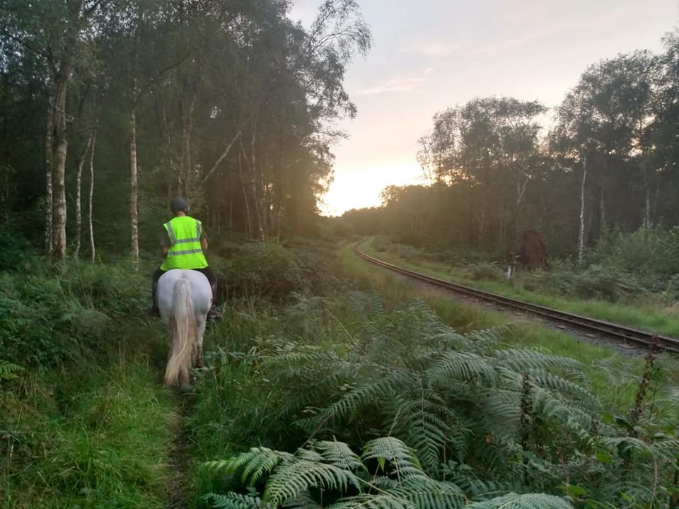
Wellbrow Drifter and Vyv Wood-Gee’s partner Chris in 2021 on the historic packhorse track along the railway on the north side of Muncaster Fell near Murthwaite. Courtesy Vyv Wood-Gee

On our map, the historic packhorse track is shown as a green line along the north edge of Muncaster Fell from Ravenglass to Murthwaite. At Murthwaite, the track turns north to go over the Mite, as suggested by Gambles. Mary Fair wrote in her article “Pack-Horse Days in Eskdale” in Transactions: “There was also a road under the north side of Muncaster Fell, following the course of the narrow-gauge railway track in places; in others it may be seen (notably near Murthwaite) adjoining the line.” (32) The photograph above shows Vyv Wood-Gee’s partner Chris and his Fell Pony Wellbrow Drifter on this historic track near Murthwaite in September 2021. In another article in Transactions in 1928, Fair wrote, “During the digging of a very deep drain for an engine pit at Murthwaite stone-crushing station of the Ravenglass and Eskdale Railway, a well-made road was cut through, with a good stone foundation and surface of rammed gravel.” (33) The well-made road may have been the historic packhorse track or even older, such as a Roman Road.

Near to Murthwaite Bridge on the map are two green circles indicating the presence of two Grounds. The Lake District National Park World Heritage Site documentation says about ‘Grounds:’ “Following a formal agreement between the Abbot of Furness and squatters in 1509, a series of permanent steadings was established by carving out small, irregular fields from the monastic commons, and building a basic, humble farmstead or ‘Ground’. Each ground is named after the original family….” (34) These Grounds are called Kitchen and Eelbeck, and families with these names could be found nearby into the 19th century. (35)

My colleague Maggie B. Dickinson considers the monastic era, roughly 1100 to 1500AD, to be the beginning of significant use of packhorses for moving goods. Places like Grounds, as part of Furness Abbey’s network, would have been serviced by packhorses. An historic packhorse track crossing the Mite at Murthwaite Bridge would have linked Furness to the south with these two Grounds. An older bridge here also would have given access to the port at Ravenglass.

Muncaster Mill Bridge is a modern bridge carrying the Cumbrian Coast Road today, but there has been a bridge at this location for centuries. Photograph © N Chadwick and licensed for use under Creative Commons 2.0 and viewable on geograph.org.uk/photo/1332148

On the map, continuing down the river nearly to Ravenglass, we see a bridge and mill. According to Gambles in The Story of the Lakeland Dales, there is evidence that a mill has existed at the site of today’s Muncaster Mill as early as the 13th century. (36) David Bradbury in his booklet The Mighty Mite calls the mill a corn mill, also indicating that in 1735 there was a kiln there for drying the grain. A stable was still on site in 1808. (37) Bob Orrell in his book Cumberland’s Rum Butter Coast says “Muncaster Mill [was], for many years, right up to the 1990s, a water-powered working corn mill and a tremendous tourist attraction.” (38) It is now a private residence. With such a long history, it is very likely that the mill was serviced by pack ponies during their era.

The bridge shown on the map near the mill is called Muncaster Mill Bridge. It now carries the Cumbrian Coast Road, but a bridge is shown at this location on a 1679 map, so during the packhorse era. (39) Mary Fair, on the other hand, says the route over this bridge is called the ‘New Road’ and dates from around the turn of the 19th century, so after the end of the packhorse era. (40) However, with the mill being located on the south side of the river and having a history back to the 1200s and the closest arable ground across the Mite on the north side, it certainly seems likely that a bridge gave access to the mill from the nearby farms prior to the 19th century and would have been used by packhorses or ponies put to carts or wagons.

Fair suggests, however, that the majority of pack horse traffic coming down the river probably crossed the Mite using the ford shown slightly down river. A packhorse track extends either direction from it, to Ravenglass on the south and towards Whitehaven on the north. In her 1928 article in Transactions called “An Ancient Ford of the River Mite,” Fair describes a causeway in the river bed with kerb stones that were visible at low tide. “As the causeway leaves the river-bed the recent floods have chewed out a bite from the North bank, where along the edge of the muddy bank, the road is seen, its east kerb having fallen into the river recently. This section shows as a line of heavy, flat stones forming apparently the road bed, with another layer of some 18 inches or 2 feet of similar stones above…” (41) She also indicates that the ancient track way heading to the north leads to a ford of the River Irt.

Fair said that at one time tolls were charged to use the ford of the Mite. Gambles in The Story of the Lakeland Dales confirms this, saying “All who crossed here had to pay a toll, and in 1703 the tolls paid here equaled all the tolls taken within the town and port of Ravenglass.” (42) Both Fair and Gambles suggest that a Roman Road crossed the Mite in the vicinity of this ford, and certainly Fair’s description of the causeway’s construction brings Roman road-building to mind.

There is a second ford shown on the map further down the Mite. This one is called Saltcoats, which Fair says was built towards the end of the 1700s. Horsedrawn traffic was still using it in 1928. (43) Gambles in The Story of the Lakeland Dales says, “The name ‘Saltcoats’, meaning salt-cots or salt-huts, suggests that this was a place where salt-pans were situated and the salt was stored in nearby huts. No record of salt-making specifically on this part of the coast has yet been found but it is known that there were extensive salt-pans further north near Maryport.” (44) As Gambles indicated above, salt was one of many items carried by packponies during their era.

Two inns are shown to the north of the fords on the road to Whitehaven. About these, Fair wrote, “Bell Hill and many of the Carleton Green tenements were taverns in pack-horse days, where trains of pack-horses could wait for the tide at Saltcotes or Mitebank to be low enough for the crossing.” (45) Farther north still on this ancient track from Ravenglass to Whitehaven but not shown on the map is a packhorse bridge across the River Irt. It is believed to date from the Middle Ages (1066 to 1485), so clearly packhorses transited this area for centuries. (46)

The last feature on the map with packhorse connections is the fishery in the estuary of the River Mite near Ravenglass. David Bradbury in The Mighty Mite says that a fish trap or fish garth was located there as early as the fourteenth century. It was sometimes referred to as Monkgarth or Mytgarth. Bob Orrell, in his book Best Guide to Ravenglass, says, “…records mention very little of Ravenglass village until the 16th century, when there is a hint of an industry associated with fish curing and exporting.” (47) Like at Burnmoor, pack ponies during their era may have been used to export fish caught at Monkgarth, just as they have been documented to have carried fish out of other parts of the region.

Finally, the Detailed Old Map shows multiple smithies [blacksmiths] in Ravenglass. It’s no wonder, given that the town was an important destination or stopping point for packhorsemen as well as drovers. Both ponies and cattle needed their feet shod to journey far and wide across England.

Miterdale today is considered one of the quietest places in the Lake District, especially above the reach of the railway. Without a through road or lake, it doesn’t draw as many visitors as other valleys. However back in the packhorse era, with the Highway traversing it top to bottom, and three routes crossing the valley, it was undoubtedly more lively than it is now. Fortunately, many of the features that are associated with the packhorse era are still visible today so that the ancestors of today’s Fell Ponies can be remembered for the key role they played in the commerce of the region.

The author is grateful to Christine Robinson for facilitating our packhorse day hike over Burnmoor in 2015, and I am grateful to my late husband who humored my desire for that journey; he is pictured in the second photo. The author is also grateful to Maggie B. Dickinson for sharing of her treasure trove of materials about packhorses and to her friend Maureen Fleming also for sharing photos. And the author is grateful to Vyv Wood-Gee for sharing her photographs of her 2021 ride in the valley of the River Esk and Miterdale.

  1. https://www.knowledge.me.uk/areas/lakes/river_mite.html as accessed July 2022.

  2. Fair, Miss Mary C. “Some notes on the Eskdale Twentyfour Book,” CWAAS Transactions, 4/7/21, p. 78.

  3. Bradbury, David. The Mighty Mite: Water power around Eskdale and Miterdale, Cumbria. PastPresented: Whitehaven, Cumbria, 2006, p. 60.

  4. Richardson, Clive. The Fell Pony. J.A. Allen, Allen Guides to Horse and Pony Breeds, 2000, p. 5. And Hindle, Paul. Roads & Tracks of the Lake District. Cicerone Press, Milnthorpe, Cumbria, 1998, p. 74.

  5. Gambles, Robert. The Story of the Lakeland Dales. Phillimore & Co. Ltd., Shopwyke Manor Barn, Chichester, West Sussex, 1997, p. 55.

  6. Orrell, Robert. Saddle Tramp in the Lake District. London: Granada Publishing Limited, 1982, p. 176.

  7. Orrell, Saddle Tramp, p. 177.

  8. Hindle, Paul. Roads & Tracks of the Lake District. Cicerone Press, Milnthorpe, Cumbria, 1998, p. 125.

  9. Detailed Old Map at https://www.archiuk.com/cgi-bin/build_nls_historic_map_archi_sub.pl?map_location=%20Fisherground%20XXXXFRMXXXX%20Cumbria&search_location=Fisherground%20XXXXFRMXXXX,%20Cumbria,%20NY1500,%20NY%2015%2000&os_series=1&is_sub=&pwd=&latitude=54.388360&longitude=-3.310447&postcode= as accessed July 2022.

  10. Bradbury, David. “The "Percy Survey" 1578, Tenants At Will In Mitredale,” PastPresented.info at http://www.pastpresented.ukart.com/eskdale/percysurvey3.htm as accessed July 2022

  11. https://www.cumbriacountyhistory.org.uk/sites/default/files/am_irton.pdf as accessed July 2022.

  12. https://www.lakesguides.co.uk/html/lgaz/LK08042.htm as accessed July 2022.

  13. Gambles, p. 55-7.

  14. Parker, Dr. Charles A., and Miss Mary C. Fair. “Bloomery Sites in Eskdale and Wasdale – Part 1,” CWAAS Transactions, 7/7/1921, p. 91.

  15. Same as #13.

  16. Bradbury, The Mighty Mite, p. 18-19.

  17. Bradbury, The Mighty Mite, p. 21.

  18. Parker and Fair, p. 90.

  19. Parker and Fair, p. 91.

  20. https://www.bowerhouseinn.com/ as accessed July 2022.

  21. https://www.lakesguides.co.uk/html/lgaz/lgazfram.htm as accessed July 2022.

  22. Hindle, p. 111.

  23. Gambles, p. 60.

  24. Bradbury, The Mighty Mite, p. 37.

  25. https://www.cumbria-industries.org.uk/wp-content/uploads/2014/06/documented-fulling-mills.pdf as accessed July 2022.

  26. Ring Cairns to Reservoirs: Archaeological Discoveries in the Duddon Valley, Cumbria. (R2R) Duddon Valley Local History Group, 2009, p. 68.

  27. Gambles, p. 59.

  28. Parker and Fair, p. 92.

  29. Bradbury, The Mighty Mite, p. 39.

  30. https://www.lakesguides.co.uk/html/lgaz/lgazfram.htm as accessed July 2022.

  31. Gambles, p. 56.

  32. Fair, Miss Mary C. “A Relic of Pack-Horse Days in Eskdale,” CWAAS Transactions, 7/7/1921, p. 99.

  33. Fair, Miss Mary C. “An Ancient Ford of the River Mite,” CWAAS Transactions, Vol 29, 1929, p. 263 as read 9/18/1928.

  34. Lake District National Park Partnership, “Description of the English Lake District, Section 2.a,” Nomination of the English Lake District for Inscription on the World Heritage List, p. 104

  35. Kitchen: https://discovery.nationalarchives.gov.uk/details/r/22fc1268-67d4-4700-81b1-814e88a423f0 and Eelbeck: https://en.wikipedia.org/wiki/Harrington,_Cumbria

  36. Gambles, p. 61.

  37. Bradbury, The Mighty Mite, p. 40.

  38. Orrell, Bob. Cumberland’s Rum Butter Coast. Seascale, Cumbria, England: Bob Orrell Publications, 2012, p. 61.

  39. https://www.lakesguides.co.uk/html/lgaz/lgazfram.htm as accessed July 2022.

  40. Fair, “An Ancient Ford of the River Mite,” p. 263.

  41. Fair, “An Ancient Ford of the River Mite,” p. 260.

  42. Gambles, p. 61.

  43. Fair, “An Ancient Ford of the River Mite,” p. 263.

  44. Gambles, p. 61.

  45. Fair, “An Ancient Ford of the River Mite,” p. 263.

  46. https://wikishire.co.uk/wiki/Drigg_Holme_Packhorse_Bridge as accessed July 2022.

  47. Orrell, Robert. The Best Guide to Ravenglass. Gillerthwaite, Ennerdale, Cumbria: Best Publishing Company, 1976, p. 5.


The Puzzle Pieces of Packhorse History

Utterby Packhorse Bridge, Lincolnshire, England

When I was a kid, my mother enjoyed jigsaw puzzles. She made them family activities by setting up a table in the middle of the living room around which we all could gather and help turn the chaos of pieces into the beautiful image on the front of the box. I learned early that shape and color and location meant something, that one puzzle piece on its own might be interesting but it was far more interesting in the context of the whole. I feel the same way about packhorse bridges in England. They are iconic items of beauty, but they are also puzzle pieces in the bigger picture of packhorse history there, a history that isn’t always visible. Since the Fell Pony played a role in that history, making the history more visible is always of interest to me! (Click here if you’d like to explore more about packhorse history in the home region of the Fell Pony.)

We saw a sign for Salter’s Lane but then couldn’t find it again when we had time for a photograph!

On a recent visit to Lincolnshire, England, I was pleased to find that a few packhorse bridges there have interpretive signs connecting them to the other puzzle pieces of packhorse history in the region. Packhorse routes developed long ago in Lincolnshire to take wool to market towns and to the port at Boston. They were also used to take salt inland. Trade in salt is dated to Roman times, and wool production peaked in the area in the 1300s when religious houses depended on it for income.

Remains of a stone causeway leading away from the church towards Utterby Bridge.

As we entered the Lincolnshire Wolds on our recent visit, which is an Area of Outstanding Natural Beauty, it wasn’t the landscape that had me nearly jumping out of the car seat. It was a road sign saying we were turning onto Salter’s Lane! My pre-trip research had indicated that such a road existed in the vicinity of one of the packhorse bridges, so I knew we were close to one. We didn’t stop for a picture though, because we were losing daylight and needed to get to our hotel. Alas, on two separate excursions over the next few days, we were unsuccessful finding the sign again. For now, a crude hand drawing is my only memento of this puzzle piece!

An historic stone causeway lies under the planted trees between the graveyard of the Church of St Andrew and the hedge along the road.

The bridge that was nearby to the sign was in the village of Utterby. Utterby Packhorse Bridge is situated next to a church, which is another important puzzle piece. The bridge’s interpretive sign says, “Just over a mile to the west of Utterby lies the site of a Gilbertine priory and lost village of North Ormsby which was established in 1184 and housed up to 50 canons and lay brothers and 100 nuns and lay sisters.” We went to where North Ormsby and the priory once stood, and indeed they are lost; there was no indication there at all of the former community or religious house’s existence.

The bridge’s interpretive sign continues, “The priory is known to have had a profitable share in the wool industry and was endowed with the Church of St. Andrew’s at Utterby. As the earliest surviving parts of St. Andrew’s also date from the early fourteenth century, it is likely that the building of the bridge was funded by the priory to improve access to the church by providing a crossing over Utterby Beck, also improving the packhorse route.”

The name ‘Porterfield’ indicates this was once an overnight spot for packhorse trains. This spot is about a quarter mile from Utterby Packhorse Bridge.

The construction of the bridge with its three stone arches also suggests it dates from the 1300s. We confirmed that tombstones in the graveyard date to at least the late 1600s; some were so badly eroded that it was hard to tell if they were older. The bridge is thought to lie on an historic saltway, which is its link to the Salter’s Lane puzzle piece. The saltway was in existence long before the church and the bridge.

Two other puzzle pieces are visible near the bridge: remains of stone causeways or human-built reinforced road surfaces. One influences the lay of the churchyard, running between the graveyard and the hedge at the road. The other runs from the churchyard outside the hedge almost to the bridge.

The final puzzle piece we found was also noted on the interpretive sign. A nearby property called Portersfield was once a stopover point for traders following the packhorse route. The name now makes that explanation obvious, but if I had seen it outside the context of the bridge, I wouldn’t have made the association!

I am grateful to the Lincolnshire County Council for their interest in the history of the packhorse bridges in the county and for the very informative interpretive signs that they’ve erected near them.

© Jenifer Morrissey, 2022

Pack Saddles and Fell Ponies

Turkey Trot Sand Lily prepared for packing equipment in canvas panniers into a logging job in a roadless area. Note that the rear girth on this saddle is farther back than would be comfortable on a male pony.

I received a question about pack saddles for Fell Ponies. And then I received another one. And then I received some fascinating information about pack saddles used during the packhorse era in Cumbria when ancestors of our Fell Ponies were an important part of transport and commerce. So I thought I had better collect the information that I have on packsaddles and Fells into one place.

Historic pack saddle at Eskdale Mill in Boot, Cumbria. It appears that the saddle and padding are integrated in this saddle. Photo courtesy Kate Hughes.

While the questions I received were about pack saddles, I consider here the topic a bit more broadly. Besides the saddle proper, there is a pad and usually some sort of container (often called panniers) which is attached to the saddle to enable loads to be carried. Sometimes there aren’t three distinct pieces to a pack outfit. For instance, the historic packhorse saddle at Eskdale Mill in Boot, Cumbria appears to have the saddle and padding combined together. And I have strapped loads directly to the saddles, as is often done with the famous Decker pack saddles, specially designed to be stronger for awkward loads.

A pack pannier system designed to be placed over a western saddle. Top: before a trash pickup project. Bottom: Before an overnight work pack trip. Photos courtesy Dawn Munro and Paula Guenther

A friend introduced me to yet another variation. She found panniers designed to fit over a riding saddle (do an internet search for Trail Max Saddle Panniers to see where to purchase them; at this writing, Amazon carries them.) Here’s what she shared after taking an overnight trip that went well: “Sometimes people face a barrier to packing with their equine because they think they need a formal pack outfit, but there are other options. The Trail Max Panniers are heavy duty and have straps in the right places. I used them with the vintage endurance trail saddle that is my normal and best fitting saddle. You can get plastic cargo boxes that fit the bags, but we did pretty well balancing the load without boxes. The only disadvantage to the design is that it is difficult to tighten the saddle’s girth with the bags full, so after the first quarter mile we needed a two-person lift-and-tighten maneuver. There is a big O ring that the rear flank cinch goes through and one at the center that can go to center D ring or pommel on saddle, whichever works better. I did remove the stirrups, fenders and leathers for a more streamlined profile. You wouldn’t have to, necessarily, and toward the end of hike out, I was pretty tempted to climb up and ride with legs cocked forward!”

When I responded to my first inquirer about pack saddles for Fells, I began at the beginning, meaning comfort of the pony. If a pony’s packsaddle is fit properly, the pony will work more willingly and safely than if the pony is asked to work with ill-fitting tack. Fitting pack saddles is similar to fitting riding saddles in that the length of the bars and ‘sit’ of the bars contributes to the comfort of the pony. For that reason, it’s important that you figure out a way to try out the packsaddle before buying, for instance by finding a local provider of packsaddles. (For an extensive article on saddle fit and Fell Ponies, click here.)

Often Fells have short backs so they require shorter bars than horses do. When I picked out packsaddles for a job for our logging and construction business several years ago, I considered both horse and burro sizes to fit the various ponies I was using on that job. I have even used a llama pack saddle on a pony, though it’s a compromise because llamas have a heavy fleece coat that allows for straighter saddle bars so extra padding is needed to fit the saddle to an equine.

Gravel being unloaded from apple-picking bags used as panniers on a packsaddle. Restar Lucky Joe is the Fell Pony.

The packsaddles I purchased for that professional job came with saddle pads. They were larger and thicker than pads for riding saddles to ensure that the back of the pony is sufficiently protected from the bars of the saddle as well as the load. Once you have the saddle and pad figured out, then you may add panniers of some sort. I have simple canvas bag-type panniers as well as apple picking bags for a gravel hauling job I did once (click here to read more). I also have nylon-lined open-top bags that I have packed greens for holiday wreaths in.

Linnel Doublet, known as Rusty, wearing an early 1900s English pack saddle while on a walk on an historic packhorse track in the Lake District.

Hynholme Amber wearing a replica of a vintage English packsaddle in the Lake District.

In 2015 my late husband and I took two Fell Ponies on a walk over Burnmoor in the Lake District on an historic packhorse track. Christine Robinson of the Kerbeck stud provided the ponies and pack saddles, to which we strapped our lunches in burlap bags. The ponies were Hynholme Amber (the black in the photos) and Linnel Doublet, known as Rusty (the bay in the photos). The two saddles were differently constructed. Christine recalls, “The saddle Rusty had on was purchased at a Vintage Traction Engine Show in Dorset. I haven't seen one like it before or after. It is actually with a friend of mine near Bristol, so I can't check exactly, but I remember it was stamped as being made in London in the early 1900s; sorry I can't remember the maker or exact date. I suspect it was Military. It also had stirrup bars on, so could be ridden on, but I'm not sure I'd fancy that! The saddle on Amber was made by my husband and was a copy of one belonging to a Heavy Horse Centre/museum. Although we use it as it is, it would originally have had pads and girth straps similar to the other one.”

Knowing my interest in packhorse history, Helen Caldwell of the Cumbria Industrial History Society sent me an excerpt from a book that is fascinating to ponder. It describes touring an historic hall in the Lake District and says in part, “Returning downstairs to the passage between the old portion and the kitchen, Mrs. Nelson, the occupier’s wife, told me that this part and the kitchen were at one time a shed. Pointing to several small remains of pulleys fastened to the beams, she said that over them ran ropes to lift the loads from the pack-horses. In the kitchen I found a pulley complete, and from this it is possible to visualize the scene in the old days. A long string of heavily-laden ponies would draw up toward evening in the yard and would then be led under this shed or porch in batches, there being arrangements to deal with about half a dozen at a time. Then, with an arrangement of ropes and hooks, the loads tied on the saddles could quickly be lifted off before the ponies were stabled for the night. The process would be reversed the next morning and considerable time would thus be saved, the unpacking and repacking of the merchandise being avoided.” (1)

It is possible that ‘to lift the loads from the pack-horses’ means to lift the entire saddle with panniers or other containers still attached. When you look at the packsaddle that Rusty wore on our trip over Burnmoor, it’s easy to imagine that that sort of packsaddle would be easy to lift by a pulley system as described. Alternatively, it’s possible that just the panniers were lifted and the saddles were removed in a separate step in the evening process. When lifting loaded panniers onto a packsaddle, it is always advisable - for the comfort of the pony and the security of the saddle - to attach both panniers at the same time to the saddle so that the saddle doesn’t try to spin from being weighted only on one side. The pulley system described here would be a tremendous help, with one person potentially being able to lift both panniers alone. Regarding ‘the unpacking and repacking of the merchandise being avoided,’ I feel this statement stems from a lack of understanding of packing. I have never unpacked the contents of the panniers at the end of the day. The whole point of having panniers or similar containers is to enable them to be removed still loaded and then be reattached in their loaded state to the saddle the next day. The pulley system described here instead provides advantages already discussed above: either enabling the entire saddle-and-panniers combination to be removed at once or the panniers to be removed by a single person.

Mowcop Black Bess putting a klibber to use for Eddie McDonough. Courtesy Eddie McDonough

Fell Ponies of course are not the only mountain and moorland pony breed that have a heritage of packing. For instance, Shetland Ponies were used extensively to carry peat on the isles of their home terrain. The packsaddles used there were called klibbers and were of very economical construction. Fell Pony enthusiast Eddie McDonough has constructed a klibber for his mare Mowcop Black Bess and has shared his design; click here for more information.

If you have read this far, you have likely concluded that there have been and continue to be a variety of pack outfits that can be used on Fells. The choice is up to the human involved in the packing project! If you are aware of other historic saddles or modern experiences packing with ponies, I would love to hear about them!

I am grateful to my ponies and to Christine Robinson, Eddie McDonough, Helen Caldwell, and my late husband for opportunities to advance my education regarding packing with ponies.

  1. Palmer, J.H. Historic Farmhouses In and Around Westmorland. Kendal: Westmorland Gazette, Ltd. 1946, p. 90.

Packhorse History in Eskdale and its Surroundings

Esk Dale is truly magnificent, full of contrasts and steeped in history.  It can also boast a unique feature in that, at its head, are the highest mountains in England, the Scafells, and its feet are well and truly in the sea at Ravenglass. – Michael Hartwell in An Illustrated Guide to the Packhorse Bridges of the Lake District (1)

Fell Pony Linnel Doublet looking out over Eskdale from the historic packhorse track between Wasdale and Eskdale over Burnmoor on the author’s 2015 traverse of the track.

The Fell Pony is the native pony of northwest England, including the Lake District.  However, the Fell is often not recognized for its many and diverse roles in the history and landscape of the northern hills.  For instance, in the nomination documents for the Lake District for recognition as a World Heritage Site, the Fell was absent despite its ancestors being the primary mode of transport of goods during the packhorse era and the Fell being a native dweller of the fells like its better-known brethren the Herdwick Sheep.  While packhorse bridges are often recognized as historic and picturesque parts of the region, the many other features that harken back to the packhorse era, including the ponies themselves, are not recognized as such.

From 2016 to 2017, Maggie B. Dickinson wrote a series of thirteen articles for Cumbria magazine about the packhorse history of the area.  Her series built on her many decades of research about packhorse bridges and related features in northern England.  Because of my interest in the working heritage of the Fell Pony, Maggie subsequently gave me permission to build upon her work and document more about how the ancestors of today’s Fell Ponies were used in the commercial and industrial past of the region.  I am grateful to Maggie for sharing her knowledge, her photographs, and her insights with me.

Wordsworth's view of the features of the Lake District as spokes of a wheel radiating from the hub (red dot) at ScaFell.  My progress documenting the packhorse history of the region is hatched in green. 

The poet William Wordsworth, in his Guide Through the District of the Lakes in 1835, encouraged his reader to imagine themselves suspended like a cloud above the Scafells where they would see diverging from their feet numerous valleys “like spokes from the nave of a wheel.” (2) In the illustration at right, the nave or hub of the wheel is shown in red. In hatched green are areas whose packhorse history I have previously explored. For instance, the packhorse history of the spoke that is the Lickle valley is in the southwestern portion of the Lake District (click here if you’d like to read that article). Clockwise from the Lickle is the spoke that is the Duddon valley (click here if you’d like to read that article.) Further north is Burnmoor and its historic route (click here if you’d like to read that article). Counterclockwise from the Lickle is the Furness region which influenced both the Duddon and Lickle valleys (click here if you’d like to read the Furness article). And then further counterclockwise are Morecambe Bay and the sands routes that crossed it (click here if you’d like to read that). Here I will explore the spoke that is the valley of the River Esk, clockwise from the Duddon valley. I will explore Eskdale’s near neighbor, again clockwise, the spoke that is the River Mite, in a future article.

As Hartwell indicates in the opening quote, Eskdale begins under the Scafells and runs to the sea at Ravenglass.  However, some sources say that Eskdale is north of the Esk and Birker & Austhwaite is south of the river.  I will use the more general rather than specific meaning of Eskdale here. 

At one time, Ravenglass was a port town, with a harbor collecting the waters of not only the Esk and the Mite but also the Irt (the next spoke clockwise from the Mite).  Maggie says about Ravenglass’s place in packhorse history, “Ravenglass has enjoyed much activity, especially during the smuggling period.  Apart from the legal import and export of goods, there were hidden dropping off and picking up points used by smugglers in the quietest of places along the coast either side of Ravenglass.  Eventually Whitehaven, a much larger harbour and port to the north, became the main base for shipping and Ravenglass fell into obscurity.”  If you haven’t read Rudyard Kipling’s poem “A Smuggler’s Song,” about pack ponies and illicit cargo, I highly recommend it;  click here to access written, spoken, and sung renditions.

Since the River Esk penetrates deeply into the Lake District, transit through its valley naturally occurred as early as humans were moving about.   Recorded history says that first defense and then trade were the primary reasons for travel through the valley.  Trade began in Neolithic times 4,000 years ago.  Then the Romans built a road through Eskdale for defense purposes in the first century AD and constructed forts at either end of the valley to oversee and protect their interests.  It is likely that they used pack ponies to access areas away from their roads.  Supporting this assertion, Sue Millard notes in her book A Century of Fells that pack saddles were found during excavation of Vindolanda, a Roman Fort east of Carlisle along Hadrian’s Wall. (3)

Subsequently, during the monastic period (roughly 1000 to 1500AD), Furness Abbey had interests in Eskdale and Miterdale and used packhorses to move goods.  And then in the post-monastic period, packhorse trains followed numerous tracks through the valley taking goods for export to the ports at Ravenglass and Whitehaven and bringing imports, legal and otherwise, on the return journey. 

Anyone interested in the history of Eskdale is indebted to Miss Mary C. Fair, an amateur historian and archaeologist who lived in the valley from 1875 to 1955. Miss Fair published numerous papers about Eskdale in the Transactions of the Cumberland and Westmorland Antiquarian and Archaeology Society (referred to here as Transactions). More recently, the Eskdale & District Local History Society completed a four-year project revisiting Miss Fair’s work, publishing Walking In The Footsteps of Mary Fair (Footsteps) in 2008. I am grateful to Jamie Quartermaine of Oxford Archaeology North for sharing a copy of Footsteps with me.

While Mary Fair’s work was principally about the Roman period and thereafter in Eskdale, she also made notes about the Neolithic period (4,500-2,350 BCE).  I was fascinated by a description of the Neolithic period in Footsteps.  Specifically, I was intrigued that “Craftsmen were fashioning the volcanic tuffs found on the high central and western fells into stone axe heads, at the time a valuable and tradable commodity.  Axes from this area have been found in large quantities in Ireland and as far afield as the northern coast of France, which suggests that the centre of the Lake District was, in a manner of speaking, a silicon valley of its day.” (4)  This telling indicates that international trade from Eskdale was actively underway up to 2,300 years BCE, which left me wondering if pack ponies were in use earlier than the Roman period.  On Dartmoor, ponies were domesticated around 1500 BCE, with horses domesticated about 500 years earlier.  (5)  Perhaps in time we’ll know more about how long ago ponies were domesticated in northwest England and if they may have helped with trade during the late Neolithic period.

copyright Jenifer Morrissey 2022

This map locates features in Eskdale and nearby areas in the Lake District of Cumbria with connections to packhorse transport, including mines, Woods, peat, mills, and more. (c) Jenifer Morrissey, 2022

The map here shows the valleys of the River Esk and River Mite, with the valleys approximated in pale yellow.  There is a low pass between the two valleys at Eskdale Green, roughly in the center of the map.  The Duddon Valley, our previous topic, sits off to the lower right of this map.  In addition to my gratitude for Maggie B. Dickinson’s assistance, I am grateful to Fell Pony trekker Vyv Wood-Gee for her interest in packhorse-related features and her sharing of photographs that you will see below.

The map indicates the rough locations of features that are related to the historic use of packhorses in Eskdale and its environs.  While ‘packhorses’ is the usual term, history says they were ponies by stature since they were usually less than 14hh; a stout but shorter equine made it easier to lift the loads onto the pack saddles.  While some of the packhorses in use during the peak of the packhorse era were imported - jaggers from Germany for instance - some were also likely locally reared and therefore ancestral to today’s Fell Ponies, the breed that calls the region home today.

Purple elements on the map indicate Roman features, including the road from upper right to lower left.  Black lines are modern roads.  Green lines indicate historic packhorse tracks that may today be footpaths or bridleways.  Often modern roads follow the same routes as historic tracks because those routes were found over time to be the most efficient way to get from point A to point B.  A narrow-gauge railway ascends the Mite valley from Ravenglass to the pass over to Eskdale and terminates at Dalegarth near Boot.  Its track is shown by a double hatched black line.  Another full-scale railway hugs the coastline.  Maggie says, “This is the Cumbrian Coast Line which runs from Carlisle and down through Workington, Whitehaven, and to the southern end of the Furness Peninsula to Barrow and then up through Ulverston, Grange-over-Sands to Carnforth near Lancaster where it connects with the West Coast Main Line” 

courtesy Vyv Wood-Gee

Fell Pony Wellbrow Drifter ambles down the old Roman road under Muncaster Fell in Eskdale in September 2021.  Copyright and Courtesy Vyv Wood-Gee

On the map, ‘Grounds’ are shown as green circles. These are current or former farms with historic associations with Furness Abbey during the monastic period. The Lake District National Park World Heritage Site documentation says about ‘Grounds:’ “Following a formal agreement between the Abbot of Furness and squatters in 1509, a series of permanent steadings was established by carving out small, irregular fields from the monastic commons, and building a basic, humble farmstead or ‘Ground’. Each ground is named after the original family….” (6) Maggie considers the monastic era to be the beginning of significant use of packhorses for moving goods, though there is evidence that the Romans used packhorses in rougher remote areas in their era. Places like Grounds, as part of the Abbey’s network, would have been serviced by packhorses.

‘Bridges’ are either known to have packhorse associations or are worthy of further investigation for packhorse associations.  Bridges have the most obvious connections to packhorses and they have been the most researched and identified.  However, some bridges have yet to be given the credit that they deserve and others are on historic packhorse routes and have been rebuilt since the packhorse era.  Maggie and others have found many bridges that are not yet on the most common lists of these important features.  Bridges are considered to be genuine packhorse bridges when they are on a known packhorse route, have low (or even no) parapets to allow panniers to pass over them, are narrow and were built during the packhorse era.  The packhorse era is generally considered to have been prior to about 1750 when the turnpike roads began to be constructed in earnest.  However, in places, road improvements didn’t come until much later, so packhorses continued in use.

‘Woods’ were forests managed historically for making charcoal and other woodland products.  As Maggie points out, some forests were coppiced:  “managed by pruning so that new growth sprouted back quickly from the roots or stumps, thereby creating wood suitable for charcoal and other purposes.”  Charcoal was the fuel source for iron smelting, an early and prominent industrial activity of Eskdale and Miterdale.  Bobbins, an example of other woodland products, were needed by the Lancashire cotton mills and were a common product of the woodlands of the region. Maggie says, “These bobbins were sent to the Lancashire Cotton Mills in the mid-1800s, and at this time the packhorses were still in full swing in such remote areas.”

Mines, quarries, and drifts are shown, though we do not have clear information about the dates of their workings.  Hence we don’t specifically know which ones would have been serviced by packhorses.  An article on the mines of Eskdale by the Cumbria Industrial History Society says, “The iron ore deposits, reddish in colour, outcrop on the surface and must have been used for ‘ruddle’ or pigments since early times. Iron has been smelted in the valley since at least Roman times, as the many small banks of slag testify. Presumably local ore was used.” (7) During their era, packhorses would have been used to move ore from mines to smelting sites.

Pitsteads are remnants of charcoal making platforms in the Woods.  Their locations are from Mary Fair’s publications in Transactions.  Pack ponies were used to transport charcoal from the Woods to the iron smelting sites called bloomeries during their era.

copyright Maggie B Dickinson

The Woolpack Inn in Eskdale has packhorse era connections. Copyright and courtesy Maggie B. Dickinson

On the map, ‘Inns, halls, castles’ are places of manorial activity, lodging and/or eating/drinking with known or probable packhorse associations. These places were near a known packhorse route. Additionally, they would have had a place for the packmen to sleep, had enclosed grass paddocks for the ponies to graze in overnight, and had space under lock and key for the packs to be stored.

Maggie adds, “In addition to the monastic system, there were other factors we inherited from the French after the Norman Conquest, like the feudal system which brought castles into being, so that with monasteries, priories, abbeys, castles, manor houses and the like, the population grew around these locations, and the need to trade became vital, so that market charters (many of which still exist) were given to towns and villages for the ease of trade, hence the need for pack ponies on routes where wheels could never go.”

‘Mills’ were water-powered so are along water courses and were used for corn as well as for processing wool and cloth (woolen, linen or hemp).  Other mills made wood products.  Prior to good road access, packhorses would have brought raw materials to the mills and taken finished products away to market. 

Bloomeries are shown on the map.  Iron ore was smelted at them, using charcoal for fuel.   Iron ore during the medieval period would have been brought to the bloomeries by packhorses or cart and horse, and charcoal would have made the short trip from the Woods to the bloomeries similarly.

‘P’ marks the locations where peat was cut and stored to be used as fuel or where evidence of its transport has been found.  In a 1984 Transactions paper by Angus Winchester, the author suggests that in Eskdale, peat was often sledged - a horse or pony put to an implement drug on the ground on which the peat was stacked.  However, he also notes use of pack ponies from some peat storage huts where sledge tracks were not found.  “The position of some of these huts near steep slopes with no evidence of well-built tracks perhaps suggests that peat was transported from them without vehicular aid, either in panniers on pack horses, or on human backs.” (8)

Finally, on the map, a church with a packhorse association is indicated, as is Hollins Farm, an overnight stop by drovers and probably packmen.

Courtesy Rob Farrow via geograph.co.uk, Creative Commons license 2.0

The descent into Eskdale from Hardknott Pass.  Bob Orrell and his Fell Ponies used this road on their Saddle Tramp in the Lake District.  Courtesy Rob Farrow via geograph.co.uk, Creative Commons license 2.0

At the far right of the map, Hardknott Pass is indicated. This is the first of several important passes into Eskdale from other parts of the Lake District. The Roman Road comes over Hardknott Pass, as shown by the purple line, connecting two of the approximately 25 Roman forts that were built in Cumbria from AD71 to AD383. The Roman roads in Cumbria were remarkably straight in most places. These are in contrast with the later packhorse tracks which tended to follow grades to make it easier on the loaded animals. And while the Roman roads connected the Roman forts, the packhorse tracks tended to connect market towns, quarries, and farms. According to the Roman Roads Research Association, “From the top of the pass the modern and Roman lines coincide but at the end of the hairpin bend that swings to right…, the Roman road diverges and takes a higher line to the fort.” (9)

In 1982, Bob Orrell published his book Saddle Tramp in the Lake District about his travels around the region with two Fell Ponies.  Bob, Thor, and Jewel traversed Hardknott Pass, with Bob expressing his appreciation for the packhorse history, and harrowing present, of the route:

…we plodded up the tortuous pass, overtaken at frequent intervals by startled motorists, surprised to find two pack-pones where they rightly belonged.  If the occupants of those brightly painted metal monsters did but know it, the horse had carried goods and people over Hardknott Pass for hundreds of years and it was the last route to be regularly used by the pack-horse gangs, before wheeled transport finally ousted them from the Lake District forever…. Descending into Eskdale we had to take great care on the smooth tarmac.  The spinning tyres of countless cars had left a coating of rubber on each bend and I had one heart-stopping moment when both ponies skied down a particularly greasy section and slid to a halt on the brink of a long drop into the valley. (10)

In Saddle Tramp, Bob also related an often-told tale about how a packhorseman was assisted by a black stallion on their travels from Kendal over Hardknott Pass on their way to Whitehaven:

The locals tell a grand story about a character who used to travel over Hardknott Pass with a gang of pack-horses, plying between Kendal and Whitehaven.  He rode a pony and, being rather fond of his ale, had a habit of dashing ahead of his pack-horse [gang] to an inn, where he would sit drinking until they had passed, led by an old black stallion who probably knew the way better than anybody.  A few more drinks and he would overtake them again and wait at the next inn.  Apparently he did this all the way to Whitehaven, but whether he managed to ride back to Kendal, or was carried, history does not record. (11)

courtesy Mountain Coward

From above Hardnott Roman Fort looking toward Eskdale. The Fort is midground center-left, and Ravenglass and the Irish Sea are at the distant upper right.  Copyright and courtesy Mountain Coward

  Hardknott Fort is one of the most impressive sites of the Roman Occupation to be found in the whole of Britain.  – Robert Gambles in The Story of the Lakeland Dales (12)

Hardknott Fort is shown as a purple diamond on the map.  While the Fort did not have known packhorse associations, it is nonetheless an important landmark in Eskdale and is accessed by the Roman Road that was later used by many packhorse gangs. 

Footsteps paints a dramatic picture of the setting of Hardknott Fort. “At the head of the valley, perched on the edge of a rim of crags, is Hardknott Fort with its impressive backdrop of England’s highest mountains. One of the best descriptions of the fort was made by Chancellor Ferguson during the first excavation in 1892. He likened it to ‘an enchanted fortress in the air; the work of superhuman powers to the native Britons.’” (13)

Robert Gambles in his book The Story of the Lakeland Dales, expands on his quote above by explaining that the impressive Hardknott Fort was actually not long-lived.  “Hardknott had a fairly short life as an active military station.  It was probably built towards the end of the first century AD and appears to have been destroyed and abandoned towards the end of the second.” (14)

According to Maggie’s research, the Roman route over Wrynose and Hardknott passes was known as Smuggler’s Road and is believed to have been the last of Cumbria’s packhorse roads.  In an article for Cumbria magazine, she told the story of moonshiner Lanty Slee.  “Not content with local trade he would use the cover of darkness to trek over Wrynose and Hardknott passes – two of the hairiest roads in the country – either leading a single packhorse with bulging panniers or among a group of smugglers, [heading] for the old Roman port of Ravenglass.  There he exchanged whisky for foreign goodies such as rum, brandy, tobacco and sugar….  On risky journeys Lanty’s whisky was frequently carried in pigs’ bladders, rather than bottles….  When his dogs gave [an alarm] signal he could split the skin and rid himself of the evidence.  The round trip from Langdale to Ravenglass on foot, of almost thirty miles, was arduous and life-threatening in inclement weather, and poses the question of when Lanty found time to sleep.”  (15)

copyright and courtesy Maggie B. Dickinson

Brotherilkeld, an historic farm with connections during the monastic era to Furness Abbey and also having more recent Fell Pony associations.  Photo copyright and courtesy Maggie B. Dickinson.

At the base of the pass, we find on the map three features: a Ground, a bloomery and a pitstead.  The Ground is referred to as Brotherilkeld (or similar spellings) and was connected to Furness Abbey during the monastic era.  Brotherilkeld has been owned by the National Trust since 1961.  According to the National Trust website, “Like many other places in the Lake District, Norse settlers and farmers left their mark through numerous place names, including Brotherilkeld meaning ‘the booth of Ulfkell’.” (16) Booth is an old English word for a livestock shelter according to Merriam-Webster.

Gambles explains in The Story of the Lakeland Dales: “In 1242 the Abbot negotiated a remarkable transaction whereby in exchange for a coastal property at Monkfoss, near Black Combe, the Abbey acquired 14,000 acres of Upper Eskdale including the already long-established sheep farm or ‘herdwick’ of Brotherilket.  They thus obtained not only a valuable economic asset but also control of the communications routes, via Hardknott, to their other possessions in High Furness and, via Esk Hause, to their farms and granges in Borrowdale.  They also secured access, via Lingcove (where their bridge still stands) and Ore Gap, to the iron furnaces in Langstrath for the smelting of the ore they mined in Eskdale.”  (17)  The bridge that Gambles mentions here is shown at the extreme upper right corner of the map. 

Brotherilkeld has connections to Fell Ponies, not only because Bob Orrell and his ponies Thor and Lucy camped there for two nights on their Saddle Tramp.   In a 2012 article in The Guardian, Tony Greenbank told a story about the Harrison family that currently stewards Brotherilkeld.  “[Eric Harrison’s] family has shepherded Brotherilkeld farm at the head of Eskdale for more than 100 years and he has farmed here for 40 years plus with his brother Geoff….  When he was eight, Eric accompanied farmer Tom Crozier and a horse called Zebe that worked on the farm to Harter's summit [Harter Fell is the tallest peak to the south of Brotherilkeld, between there and the Duddon Valley].  Eric had hoped – as boys will – to hitch a ride on the sturdy fell pony, but Zebe (which always wore a chain so it could be readily caught when it trod on the links) was carrying a bag of cement needed to make a platform for the Ordnance Survey trig point on top. Eric was forlorn to find that neither could he ride down. The steep angle tipped him headlong over the horse's head, down towards the leafy belt of trees by the river Esk.…”  (18)

copyright and courtesy Maureen Fleming

Lingcove Bridge over a headwaters tributary of the River Esk.  Photo courtesy and copyright Maureen Fleming

Not far from Brotherilkeld on the map is a marker for a bloomery and pitstead. These features are mentioned in Mary Fair’s 1921 Transactions paper called ‘Bloomery Sites in Eskdale and Wasdale (Part 1)’: “To the right of the road ascending [Hardknott] pass about 50 yards over the bridge are remains of a hearth or kiln, the bottom of which is covered with burnt matter…I have not been able to find a slag-heap, but through the gate above, at the right beside the ancient track leading from a ford, is a heap of iron ore. There are charcoal pitsteads in the wood at the opposite side of the road from the hearth.” (19) During their era, pack ponies would have moved charcoal from the pitstead to the bloomery and ore from mines to the bloomery.

Above Brotherilkeld over a tributary of the River Esk sits Lingcove Bridge, also called Throstlegarth or Roman Bridge.  It physically has the characteristics of a packhorse bridge in terms of width and low or no parapets.  However there is disagreement about it being on a known packhorse route.  Hinchliffe, widely considered one of the best authorities on packhorse bridges, wrote in his book A Guide to the Packhorse Bridges of England, “It is said to be on a route leading from Brotherilkeld via Ore Gap into the Langstrath valley where there was a smelting furnace or bloomery; a route used by iron miners.  This is difficult to confirm from present evidence because the path between Brotherilkeld and Ore Gap is on the same side (east) of Lingcove Beck throughout.” (20).  Gambles says in the quote above that the bridge has monastic connections, which would confirm its connection to packhorses since Furness Abbey made significant use of pack ponies.  Hartwell in his book on packhorse bridges also indicates monastic connections, “There has probably been a crossing at Throstle Garth for hundreds of years….  The monks from Furness Abbey had a monastic sheep pasture around Throstle Garth Bridge where the remains of the sheep folds are still in evidence.” (21) 

Also above Brotherilkeld are locations of peat moss.  In Winchester’s 1984 Transactions paper called ‘Peat Storage Huts in Eskdale,’ he wrote, “A survey of these peat storage huts in Eskdale was undertaken in August 1982, with the help of a small group of American volunteers, recruited by the Earthwatch organization of Belmont, Massachusetts, as part of a project organized by the Brathay Centre for Exploration and Field Studies…. What is unusual about the Eskdale huts is their location out on the fellside: most other Lakeland ‘peat houses’ were situated among the other buildings of the farmstead….  All that can be said with certainty about the origins of the peat scales is that some, at least, were in existence by the late 16th century.”  (22)  Pack ponies would have been one form of transport available at the origins of these peat scales.

During the survey of Eskdale peat scales, thirty-five huts were located, and two types were identified.  Type A huts were more primitive and likely went out of use in the mid-1800s.  Type B huts had slate roofs on their stone walls, as compared to bracken on the Type As, and the Type Bs “were nearly all associated with well-made sledge tracks and several had stone-built ramps leading to their upper doorways and levelled areas in front of their lower entrances….  The absence of the [Type B] storage hut from the upper reaches of the valley may indicate that the smaller deposits of peat in that area had ceased to be worked (or had been worked out) by the date of the change of building style.” (23)  On the map, the three indicators marking Peat are from this survey, with two of the three being Type A huts and the third, the farthest north, being a hut of unclassified type.  Pack ponies were known to carry bracken, so it’s possible that the construction of the Type A huts may have involved them.

by Mick Knapton and used via Creative Commons License 3.0

Wha House Bridge over the River Esk.  While not considered a packhorse bridge, its location suggests that a bridge likely existed in this location during the packhorse era.  Photo by Mick Knapton and used via Creative Commons License 3.0

Traveling down the river and the Roman Road we come to a bridge over the River Esk. Wha House Bridge is not considered a packhorse bridge. However, its location both topographically and on the Roman Road suggest a bridge in this location likely existed during the packhorse era and would have been used by packhorses. With a known packhorse route on the south side of the river and the Roman Road providing good transit on the north side of the river, and with packhorse-related features on both sides of the river, it seems likely that a bridge at the Wha House location would have been an important feature, just as it is now for modern vehicular traffic.

There are three mines, quarries or drifts shown north and south of Wha House Bridge.  These features were located via a map called ‘Detailed Old Victorian Ordnance Survey Map 1888-1913.’  This map, which I will refer to as Detailed Old Map, has been a valuable resource for investigating routes, tracks, and bridges as well as the location of peat moss, quarries, mines and drifts.  (24)

copyright and courtesy Maggie B Dickinson

Doctor Bridge across the River Esk is an important link between numerous historic packhorse routes.  Copyright and courtesy Maggie B. Dickinson

A green line on the south side of the river heading west from Wha House Bridge is an historic packhorse track according to Bob Orrell in Saddle Tramp: “…having spent much of the morning talking to the Harrisons [at Brotherilkeld], the day was well advanced when I rode Thor down to Wha House bridge and a gate leading into a tree-lined meadow. The old pack-horse track crossed the meadow to a wood and on through bracken, so tall at times the ponies were out of sight under it. Crossing the boulder-strewn beck, the track improved, following a well-worn route through pasture land and numerous gates, to Penny Hill Farm. In the days when packhorses and droves of cattle passed by from Ravenglass, the farm was an inn called Pyet’s Nest.”(25) On the map, Pyet’s Nest is indicated. Maggie suspects Pyet is a surname.

Continuing on from Penny Hill Farm, still on the south side of the river, we come to a bridge across the Esk.  Today the bridge is called Doctor Bridge, and there is a popular tale from 1734 about a local surgeon living at Penny Hill.  It is said he wanted the original packhorse bridge at this location widened to accommodate his pony and trap.  However, Gambles and colleagues published an article in the Friends of the Lake District’s newsletter Conserving Lakeland that tells an alternate interpretation of the bridge’s widening. 

According to the article, documents uncovered at Penny Hill Farm say the bridge was widened circa 1817.  In addition, the bridge wasn’t called Doctor Bridge until 1860 or so on an Ordnance Survey map.  “So the link between the ‘doctor’ and the ‘bridge’ is by no means proven,” say the article’s authors.  Nonetheless it is clear from its location that it was an important feature during the packhorse era.  Hartwell says in his book on packhorse bridges, “…although today it provides access to only two or three farms, it was (in the 1700s) on an extremely busy route.  In fact, it was on the main thoroughfare between Esk Dale and the Duddon Valley.” (26)  There is a picture of this ‘main thoroughfare’ below.

The indications of peat on the map south of Doctor Bridge and Penny Hill were identified by Winchester in his 1984 Transactions paper.  Three in the more eastern location were Type A, or older, and the more westerly one was a Type B or newer and more elaborate.  Winchester asks an interesting question in his paper after reviewing a relevant lawsuit: “an attempt must be made to consider why the inhabitants of Eskdale went to the expense of building such structures, while many other Lake District communities seem to have succeeded in obtaining their peat without storage huts on the commons.  The reason given in the 1795 lawsuit papers… was that ‘it is often difficult to win their peats in summer’. Presumably, the phrase ‘to win’ is used here to cover the whole process of obtaining peats, from cutting them to bringing them to the farmstead. Inability to complete the process in the summer could arise from two factors: either the climate on the exposed, high level peat mosses might have been too wet to allow the peats to dry sufficiently, or perhaps, aggravated by the slowness of drying, the farming calendar of the summer months (hay-making, sheep clipping, harvest) might not have allowed sufficient time to carry the peats down….  It may be argued that precipitation in Eskdale is not appreciably higher than elsewhere in the Lake District and that climate alone cannot explain the need for peat scales in the valley. The relatively high altitude of the peat deposits would account for some difference in climate between the Eskdale peat mosses and those of some other valleys, but the decisive factor may perhaps have been the extremely steep fellsides of Eskdale which separated the farmsteads from their peat supplies. It might well have been considered preferable to carry completely dry peat down these at intervals during the winter than to carry the extra weight of water in crumbling, semi-dried peats in the summer.” (27)  Certainly if pack ponies were used to carry the peat, having the peats be drier and lighter would allow a larger load to be more safely carried down the steep tracks.

On the map, the mine noted south of Penny Hill is an old copper mine.  Its location is documented in the 1923 list of Ancient Monuments in Birker and Austhwaite.  (28)  No indication of the dates of its working were given, so it’s unknown whether it would have been serviced by pack ponies.

Woods are indicated on the map along the river downstream from Doctor Bridge.  The Detailed Old Map names the first pair Oak How and Crag Coppice and the downstream pair Ash How and Great Coppice.  Mary Fair refers to them as Birker Wood, and she found numerous pitsteads there.  According to Maggie, ‘how’ is Norse for hillock. 

A bloomery is indicated on the map between the two pairs of Woods.  Mary Fair calls the bloomery Low Birker and she also locates pitsteads in a Wood nearby.  “[The bloomery] is situated on the ancient road on the south side of the Esk….   In the field at the other side of the wall there are heaps of oxide mixed with metallic ore on the banks of the stream, and red oxide and slag are scattered here and there in the earth of the field lately turned up by the plough….  There are numerous charcoal pitsteads in Birker Wood.” (29)  Charcoal would have been moved from the pitsteads to the bloomery by packhorse during their era.  Ore may also have been moved to the bloomery the same way in that era.

copyright and courtesy Maggie B Dickinson

Sign marking the site of the historic Woolpack Inn.  Copyright and courtesy Maggie B. Dickinson

Across the river from Doctor Bridge and Penny Hill Farm, two features lie on the Roman (and modern) road. The first is a bridge across a tributary of the Esk, and the second is an inn. The bridge crosses Blea Beck and is called, suitably, Blea Beck Bridge on the Detailed Old Map. Like Wha House Bridge, it is not considered a packhorse bridge but a bridge at this site likely existed during the packhorse era when a route likely followed the Roman Road.

copyright and courtesy Eddie McDonough

Herdwick sheep and spectators at Eskdale Show in 2015 with the dramatic fell backdrop.  Courtesy Eddie McDonough

The inn, on the other hand, has known packhorse associations and is pictured above. The Wool Pack Inn, according to Mary Fair, was originally called the Dawson Place. (30) And the Old Cumbria Gazetteer website calls the location Dawson Ground, hinting at a possible historic connection to Furness Abbey. (31)

A visitors’ guide website says, “The isolated Woolpack Inn and the nearby Youth Hostel are well frequented by hill-lovers for most of the year, but on the last Saturday in September the narrow road is thronged for the Eskdale Show.” (32) 

The Eskdale Show history page once included this tidbit about the Woolpack and the iconic Lake District sheep breed the Herdwick: “In some of the early years, over 500 [Herdwick] tups came to Eskdale Show, the majority of which would be walked there, taking several days to reach the Woolpack. For example, Keswick sheep would be walked up Borrowdale then over Styhead Pass into Wasdale, then over Burnmoor Tarn track into Boot and on to the Woolpack. In 1867 there were entries from as far away as Threlkeld, Buttermere, Windermere, Coniston and Cockermouth. It would have been a tremendous sight seeing all the Herdwicks converging into the Show field.” (33)

copyright and courtesy Maggie B Dickinson

Hollins Farm in the 1970s.  The name 'hollins' indicates it was used by drovers when moving cattle and may have been used by packmen in their era.  Copyright and courtesy Maggie B. Dickinson

Down the Roman Road from the Woolpack Inn and slightly north is Hollins Farm. The name ‘Hollins’ indicates the farm was once used by drovers for overnight stops. Maggie says it was possibly also used by packmen. On the Detailed Old Map, numerous tracks are shown to the farm, including coming down Whillan Beck connecting to the historic track from Burnmoor.

Along that track, a mill is shown called Gill Bank.  On the Detailed Old Map, it is labeled a sawmill.  The Cumbria Industrial History Society says it was a carding mill in 1810. (34)  Carding mills prepared wool for spinning by brushing the fibers to evenly align them.  The PastPresented website includes a collection of deeds for Gill Bank Farm beginning in 1696, with a miller in residence as early as 1754, as well as a weaver.  Starting in 1813, the noted poet William Wordsworth owned Gill Bank Cottage for a time.  ‘Peathouses’ are also mentioned in 1813. (35)   On the Old Detailed Map, a bridge is shown crossing Whelan Beck between the farm and the mill.  It is possible that pack ponies would have serviced this mill and the peat houses prior to improved access.

Continuing down the Roman Road from Hollins Farm is the village of Boot.  According to Hartwell in his book on packhorse bridges, “The name ‘Boot’ is derived from the Viking for ‘dwelling place.’” (36) 

courtesy Maggie B Dickinson

Postcard of Gill Bank(s) Mill, north of Boot, circa 1920. Courtesy Maggie B Dickinson

The History page of the Eskdale website elaborates on the Viking/Norse period of the region’s past. “The most influential settlers, though, were the Norsemen in the 9th and 10th centuries. These were not the loot-and-pillage Vikings who swept the east coast but farmers who recognised the landscape from their homeland….Many of the thick walls at Boot and Brotherilkeld are a result of their [Viking] land clearance. Their language is also still very much alive in many of Eskdale's names, like Blea Tarn, Scafell, Birkerthwaite, Scale Gill and Dalegarth.” (37) Thwaite, for instance, means clearing in the forest.

Boot Bridge in 2015 with two Fell pack ponies and the author, right, and Christine Robinson, left.

Between the Woolpack Inn and the village of Boot, there are numerous quarries, mines, or drifts indicated on the fellside north of the river.Gambles, in The Story of the Lakeland Dales, says, “Eskdale’s iron ore was mined for close on 2,000 years from Roman times until the last venture ended in 1913. The haematite outcrops may best be seen on the fellsides near Boot.” (38) Those more recent mineral mining ventures as well as an interest in the local granite inspired the building of the narrow-gauge railway that dominates the experience of many Eskdale visitors today and which also of course put natural horsepower out of business.

My introduction to Boot was quite different from that of most modern visitors.  It was via, not surprisingly, a packhorse bridge.  Boot Bridge (also called Mill, Eskdale or confusingly Bleabeck) crosses Whillan Beck, a tributary of the Esk.  The bridge gives access from Boot to an historic corn mill.  It is also on an important packhorse route to Burnmoor and thence Wasdale.  The route over Burnmoor to Wasdale was also a corpse road; click here to read more.

copyright and courtesy Maggie B Dickinson

Eskdale Mill in Boot on the left with Boot village ahead over the packhorse bridge and used millstone in right foreground.  Copyright and courtesy Maggie B. Dickinson

Bob Orrell points out in his book Cumberland’s Rum Butter Coast that, “Eskdale is one of the few valleys in Cumberland that does not have a lake you can sit by, but in the hamlet of Boot close by the station, there is Eskdale Mill, that has a recorded history going back to 1294 and is claimed to be one of the oldest water-powered corn mills in England.”(39)

The mill’s website is very informative.  For instance, it says that “The earliest millstones would have been made from English millstone grit brought here from the Pennines.  Cologne stones from the Rhineland were probably installed during the middle of the 1700s to grind imported wheat.” (40)  The Pennines lie to the east of the Lake District.  Since those earliest millstones were installed prior to the mid-1700s, it begs the question of if and how natural horsepower would have been used to move them from the Pennines to Boot.  Perhaps over Hardknott Pass?  Or by boat to Ravenglass and then up the Roman Road somehow?  So far, Maggie has been unable to discover how the millstones were transported.

The mill website then goes on to say, “People began to combine water-powered corn mills with corn-drying kilns during the 18th and 19th centuries. These kilns were needed to dry out the damp grains, particularly oats, in the colder and wetter areas of Britain, including the Lake District. They could then be ground effectively by the millstones. At Eskdale Mill a permanent, purpose-built kiln was added between 1795 and 1819, using locally-cut peat for fuel. Since at least the 1500s Eskdale people had enjoyed the right to cut turves of peat from the common land. Peat was cut from the moorland above the mill.”  (41)

The mill website also says, “Farmers usually delivered their grain to the mill themselves, but the miller would return the ground flour using his own horse and cart.”  (42)  Maggie points out in her Cumbria article about mills that this mill is a ‘bank’ mill, taking advantage of the sloped terrain.  “The pack teams climbed to the higher ground at the rear of the split-level structure to access the drying kiln, where their panniers could be directly unloaded to avoid hoisting.  Oatmeal and barley were the most popular local grains for milling because wheat was a luxury and tended to be grown on the coastal plain.” (43)  The transport of peat to the kiln of course might also have been accomplished by pack pony.

Courtesy Kate Hughes, Eskdale Mill manager

Historic pack saddle at Eskdale Mill in Boot. Courtesy Kate Hughes, Eskdale Mill manager

Of particular interest to us at the mill today is an historic packhorse saddle.  Hinchliffe says in his 1994 book about packhorse bridges regarding the pack saddle display at that time: “The small exhibition inside the mill displays a padded wooden packsaddle on which were loaded two sacks of corn.  The display also notes that there was once a regular weekly gang of 20 packhorses en-route through Boot from the west to cross Hard Knott and Wrynose on the way to Ambleside.  From Boot they would probably cross the other Eskdale packhorse bridge - Doctor’s Bridge.” (44)

Fell Pony Hynholme Amber looks toward a peat storage hut along the track from Boot to Burnmoor in 2015.  From this perspective it appears to be a Type B or more modern peat scale.

On the map, along the historic track from Boot north to Burnmoor and Wasdale, peat activity is indicated, as suggested by the mill website. In Winchester’s 1984 paper on peat storage huts in Eskdale, he wrote, “The largest concentration [of peat scales] is the cluster of nine huts on Boot Bank at the head of the track from Boot to the peat mosses on Longrigg.”(45) The photo here shows a hut near Longrigg. I didn’t know at the time that I took the photo that the structure had packhorse associations, or I would have gone to investigate! From this photo it appears that this is what Winchester in his Transactions paper describes as a Type B or more modern peat scale, built to take advantage of the slope so that horse or pony drawn sledges could be pulled to the top to unload fresh peat and to the bottom to load dried peat for transport to Boot village below.

The historic packhorse track from Wasdale and Burnmoor continues through Boot to the south.  First the track passes a Wood, called Hows Wood on the Detailed Old Map.  The track then stops at the only church shown on the map.  The reason St. Catherine’s Church is shown on the map is that the historic route from Wasdale was not only used for movement of goods and livestock but also as a corpse road.  Bob Orrell in Saddle Tramp explains, “In the days before Wasdale Head had its own consecrated ground, those unfortunate enough to expire in this remote corner of Cumberland were denied their final rest until the mortal remains had been carried, on horseback [over Burnmoor], for burial to St. Catherine’s in Eskdale.” (46)  To read more about this corpse road including the numerous ghost stories associated with it, click here.

Across the river from St. Catherine’s, numerous features are shown on the map.  The mines that are indicated are from the Detailed Old Map which shows numerous old drifts.  Mary Fair confirms these features.  The Detailed Old Map also shows Force Wood along the tributary of the Esk that is called Birker or Stanleygill Beck. 

The location of the bloomery is from Mary Fair’s work.  She called it Underbank Wood, indicating another Wood was in the area.  “This is across the river from the old church, a little to the east…  During the time in the 19th century when iron ore was mined at Boot, operations were also carried on here. A bridge was built across the Esk carrying a waggon-way to an adit in the fell side, now fallen in. There are other numerous shafts sunk in the fell side. The waggon-way joined the railway (crossing the high road and the Whellan Beck), between Boot and Beckfoot.” (47)  If operations were carried on here before the 19th century, then this bloomery may have been serviced by packhorses for ore and for charcoal.  And of course it’s possible that the wagons were sometimes pulled by ancestors of today’s Fell Ponies, if not by horses.

courtesy Mountain Coward

Ellerbeck Bridge. Courtesy Mountain Coward

Going up Birker Beck past Force Wood, there are two Grounds and two bridges. The Grounds are called Low and High. Being Grounds, they have an historic connection to Furness Abbey which was a major user of packhorses and builder of packhorse bridges. The two bridges in the area are called Whincop and Ellerbeck, and for numerous reasons they are worthy of further investigation as packhorse bridges. Their proximity to the Grounds, their proximity to a major route to the Duddon Valley, and because of their appearance all suggest that they could be genuine packhorse bridges.

Whincop Bridge. Courtesy Mountain Coward

Downstream on the south side of the Esk from Birker Beck we see a cluster of features: an Inn, a bloomery, a pitstead, a bridge, and a Wood. The Detailed Old Map locates Newhall Coppice and Low Wood here. The ‘Inn, Hall, or castle’ is Dalegarth Hall, the subject of a 1928 Transactions paper by Mary Fair. The paper’s introduction explains how far back the place has been inhabited.“ The ancient habitation on the south bank of the Esk known today as Dalegarth Hall is of interest on account of its long association with a branch of the distinguished family of Stanley [who farmed in the valley for over 500 years…].It is a matter of general knowledge that the original name of the estate was Austhwaite, the occupants taking their name from it, the manor being granted by one of the Boyvilles in 1102 to the family styling itself de Austhwaite who remained in possession till about 1345 when the line became extinct in male succession, the heiress, Constance daughter of Thomas, the last de Austhwaite, marrying Nicholas Stanley of Greysouthen. We first hear of Dalegarth in 1437, when Thomas Stanley, great-grandson of the above Nicholas, is recorded as being of Dalegarth when he married Anne Hudleston.” (48) It is clear from this long history that packhorses would have serviced Dalegarth Hall for some time.

In her 1921 Transactions article on bloomery sites in Eskdale, Mary Fair describes the nearby bloomeries and pitstead.  “There are two (if not more) bloomery sites here….  [No. 1] is situated about 100 yards through the wood east of the gate by Turn Dub. There is a small heap of slag on the old road, another to the right in the wood, and over a wall to the left, more heaps of heavy slag on the bank of a small runner. No trace of hearth. There are heaps of charcoal in the vicinity, and pitsteads in the wood….  No. 2 is in the wood beside the road immediately behind Dalegarth Hall. This appears to have been a more extensive working than the other, judging from the slag-heaps. There are also the remains of a hearth which is about 20 feet in external diameter at the top. There is a well-defined channel or conduit leading from the bottom to a trough made of rough masonry. Adjoining are small heaps of charcoal and patches of oxide puddle.”  (49)

She continues, “I have been told by a dalesman that his grandfather could remember the smelting of iron in the woods in the old rude way, so that many of these small sites may be comparatively modern. Iron ore abounds in the fells all round Eskdale, and no doubt has been worked from early times. Every wood contains numbers of charcoal pitsteads, and the number of the bloomery sites suggests that the iron required for the dwellers in the dale was smelted locally….” (50)  She concludes that many of the smaller bloomeries were of 17th, 18th, or early 19th century origin with two others being possibly Roman.  It’s likely then that packhorses brought ore and charcoal to them at least in the earliest years.

South of Dalegarth Hall, peat is indicated.  In Winchester’s 1984 Transactions paper on peat storage huts, he indicates that the storage hut in this location was owned by Dalegarth Hall and was a Type B or more modern hut.  The Detailed Old Map shows Tonguesdale Moss in this vicinity.  Winchester says, “The change to a more substantial type of hut may have been associated with the construction of durable, graded sledge tracks up to the peat mosses, and it may also have been related to a concentration of peat-digging in the extensive mosses between Blea Tarn and Burnmoor on the north and around Low Birker Pool and Tonguesdale Moss in the south.” (51)  Peat at Low Birker Pool is indicated just east of Whincop and Ellerbeck Bridges.   Winchester noted on his map in his paper that there is evidence of former peat cutting at both Low Birker Pool and Tonguesdale Moss.  It seems likely that early peat cutting could have been assisted by pack ponies, and then later sledges were horse (or pony) powered.

copyright and courtesy Eddie McDonough

The historic track, now motor road, between Eskdale Green in Eskdale and Ulpha in the Duddon Valley. 
Courtesy Eddie McDonough

The bridge in the vicinity of Dalegarth Hall is called Trough House Bridge.  Maggie says that Dr. Sam Forrester, a respected historian of the Lake District, mentions in his papers at Armitt Museum that Trough House Bridge is a widened packhorse bridge.  Certainly its location alone suggests that would be the case since it crosses the River Esk and connects Boot to the heavily used route to the Duddon Valley. 

Across the river from Dalegarth to the north are two bloomeries.  In her article on bloomeries in Transactions, Mary Fair names them Stanley Ghyll Guest House and Vicarage Glebe.  Regarding the first, “Two slag-heaps in the garden here, near to the river Esk. Owing to disturbance of ground due to making the garden, the scope of the work cannot be traced. Before the building of this place, the ground was open common.” (52)  According to the Guest House’s web page, the house was built in 1894 by the then-owner of the Woolpack Inn. (53)

Regarding the Vicarage Glebe bloomery, Mary Fair says, “Many years ago I noted a small heap of heavy slag under the bushes on a steep bank beside the river Esk, about 50 yards below the Dalegarth [Trough House] Bridge. It is now quite overgrown, and not to be located. No hearth found. A little lower down the river it is probable that there was a ford giving communication between Dalegarth Hall and Beckfoot (now the vicarage).” (54)   Depending on when these bloomeries were in use, they may have been serviced by pack ponies hauling ore and charcoal.

Near Trough House Bridge, we see a second bridge indicated on the map.  Beckfoot Bridge crosses Whellan Beck near its confluence with the Esk, along the ancient route of the Roman Road that is now a modern road.    While today’s bridge is not a packhorse bridge, it seems entirely reasonable to assume that there was a bridge in this vicinity during the packhorse era to facilitate movement of goods along the north side of the river. 

copyright Jenifer Morrissey 2022

Map showing the historic tracks down from peat beds such as Sineytarn Moss to peat scales (P) for storage and then to the farms where peat was used for heating.  Note the switchbacks in places, indicating steeper sections of the tracks. According to Winchester, the peat scales shown were owned by Vicarage, Spout House, Fisherground, and Hollinghow. (55) (c) Jenifer Morrissey, 2022

At Beckfoot Bridge near the confluence of Whellan Beck and the Esk, an historic packhorse track is shown heading up to Blea Tarn. In Winchester’s paper in Transactions about peat storage huts, the historic track is shown on his map with two peat scales along it, one of each type. He suggests that the newer one likely replaced the older. The track is full of switchbacks, making it easy to imagine how useful pack ponies would be to bring the turves down from the peat scales to the farm below before the track was improved into a sledway.

Gambles in his book The Story of the Lakeland Dales paints a vivid portrait of the role these peat scales played: “…there is a wealth of interest in the variety of the landscape and in the history of the generations of men and women who have lived, worked and died there.  No reminder of these people could be more poignant than the ruins of the many tiny stone huts scattered on the moors between Blea Tarn and Burnmoor.  Some are built like miniature bank barns, others are plain, low structures with simple gables; all are of the local Eskdale granite and when new, must have made a welcome splash of colour on these drab uplands.  They have been identified as peat storage huts, or peat scales, where local folk left their cut peat to dry, later to be taken down along sledways, some of which can still be traced.  The depletion of the woodlands had by the mid-19th century made it necessary for them to seek out the deep peat deposits on the moors as an alternative source of fuel for cooking and to heat their cottages.  It is easy to forget in an age of electricity and central-heated comfort that such basic necessities of life had to be won by so much constant effort and hard labour.” (56)

The peat indicated on the map above Blea Tarn is shown on the Detailed Old Map as Mitredalehead Moss with White Moss above it.  To the west the peat indicated is Sineytarn Moss with its own historic track down to the farm at Spout House with two peat scales en route.  Further to the west, a pair of peat storage huts are indicated along an historic track to Fisherground, which Winchester says owned one of the huts.  While now a campground, Fisherground’s name implies an historic connection to Furness Abbey and thus to pack horses. 

copyright and courtesy Vyv Wood-Gee

Vyv Wood Gee captions this photo from her 2021 ride in Eskdale:  “Murthwaite Posh questioning the date and origin of the bridge over the River Esk east of Muncaster Head.”  Forge Bridge is definitely more modern than the packhorse era but is in a location where a bridge during that era may have existed.  Photo copyright and courtesy Vyv Wood-Gee

In the same vicinity, the Detailed Old Map shows numerous pits, drifts, and quarries. A history of Eskdale mining says about this area that “The workings [of a nineteenth century mine] overlie an extensive earlier landscape consisting of a complex of settlement and agricultural field-system remains, as well as peat huts and sledways ascending from the valley floor at Fisherground.” (57) This earlier worked landscape was likely serviced by packhorses during their era.

South of the river from Fisherground, the historic track snugs the river from Dalegarth Hall through Milkingstead Wood to Forge Wood and Forge Bridge.  The names would certainly make one think that metalworks had been undertaken here, and a bloomery and pitstead are shown on the map.  Mary Fair says in her Transactions article on bloomeries:  “There is a bloomery site in a small paddock adjoining the farm now called the Forge Farm. The old name of this farm is Howe Howe or Howe Powe. It has only been known as the Forge Farm comparatively recently. The ground has been ploughed though now pasture, but the tenant (Mr. William Southward) informs me that a quantity of slag and cinders is scattered about over the field under the grass. I saw plenty of heavy slag and clinker in the dyke bank dividing the field from the wood, and also on the banks of a runner at the foot of the wood. No traces of hearth. There are numerous charcoal pit-steads in this wood, and Mr. Southward tells me that he remembers charcoal being burned there.” (58)  It is unclear whether the activities described here were during the packhorse era and whether there may have been earlier activity. 

copyright Jenifer Morrissey 2022

Eskdale Green and its convergence of many packhorse tracks.  Noted features are mentioned in the text.  (c) Jenifer Morrissey, 2022

The village of Eskdale Green sits northwest of Forge Bridge on a slight rise between the Rivers Esk and Mite. Mary Fair wrote extensively about Eskdale Green’s many ties to the packhorse era in her 1921 paper in Transactions called “A Relic of Pack-Horse Days in Eskdale.” Eskdale Green was important because it was a converging point of numerous historic packhorse tracks.

Above is a map showing the many tracks converging on and leaving Eskdale Green, including locations of key features from Mary Fair’s article.  The two rivers are in light blue, with the Esk lower right and the Mite extreme upper left.  The route along the Roman Road to Hardknott Pass and thence Ambleside is on the right in purple, and at lower right is the route along the south side of the river that eventually leads to the Duddon Valley and then Broughton-in-Furness.  There are three routes to Ravenglass shown, one on the north side of Muncaster Fell which begins mid left and the other two on the south side of Muncaster Fell, one on each side of the Esk.  The route on the north of the river on the southside of Muncaster Fell begins lower left.  The route on the south side of the river is shown lower right.  There is a road connecting Eskdale Green to Muncaster Head and the Roman Road across the east side of Muncaster Fell.  And there are three routes leading out of Eskdale Green to the upper left and top toward Whitehaven. 

Mary Fair identifies a blacksmith at Randlehow (center of map) and another blacksmith below the King George Hotel, shown as King of Prussia Public House on the Detailed Old Map and here, center right.  And she identifies a third blacksmith from the name Smithybrow Lane at the top of the map.  Maggie says, “There must have been many forges in the days of horses, especially with the traffic that the area had from packmen and drovers.” 

Mary Fair also describes a second inn besides the King George:  “Near Eskdale Green railway station there was a tavern on the pack-horse route, now marked by a barn. The sign of this tavern hung in a tree. Probably it, like John Nicholson's smithy above it, did an excellent trade when the commerce of the country-side was carried on by the trains of packhorses.” (59)  Mary Fair doesn’t draw attention to nearby Whinnyhow Wood, but it certainly has a connection to equines in its name! 

copyright and courtesy Vyv Wood-Gee

Fell Pony Wellbrow Drifter traverses an historic packhorse track, now a bridleway, from Eskdale Green along the southern end of Bankend Wood. Courtesy Vyv Wood-Gee

Two bloomery sites are shown on the map in the vicinity of Eskdale Green. Mary Fair identified these in her Transactions paper on bloomeries in Eskdale. During the packhorse era, charcoal and ore would likely have been brought in with packhorse assistance. The peat south of Eskdale Green is shown on the Detailed Old Map as Forest Moss, which Mary Fair tangentially mentioned in her packhorses Transactions paper: “Beyond the [Randlehow] smithy another road came across the bog [emphasis added] from an ancient track passing across towards Whitehaven from Muncaster Head direction. There is still a right of way across this soft ground.” (60) This track is noted on the map with a red arrow captioned “Muncaster Head and Roman Road.”

The historic track leading south out of Eskdale Green over Forest Moss passes a bloomery and Bankend Wood.  Footsteps says, “Near to Bank End is the site of an old ‘bloomery’ – an iron ore smelting hearth – which would produce sufficient iron for local needs….”  (61)  Mary Fair in her Transactions paper on bloomeries locates this bloomery at Forest Howe, and in another Transactions paper she locates it at Rabbit How, all in the same vicinity (62).  In her bloomeries paper, she wonders whether it could be Roman in origin.  She asked the same question about Muncaster Head (described below), but subsequent excavation pinned that site to the 17th century and after. (63)  It is likely, nonetheless, that packhorses would have been used to service this bloomery, hauling charcoal and ore, during their era.

Footsteps gives an interpretive account of an historic tenant of the local farm:  “Here in Eskdale [in 1493] Will Tyson looked at his scanty crop of oats and pulled a heavy peat sled down Rabbit How for his winter store.  His son, also Will, was up on the fellside cutting coppice for the forge’s charcoal.  In the longhouse his wife was spinning the coarse grey wool while a skillet of hare simmered and hams smoked above the fire.  The bracken thatch was letting the rain in and the hogg runts [lambs] were churning up the beds of ling [heather] on the damp dirt floor.” (64)  This account suggests that peat was brought in using human rather than pony power.  The telling could be artistic license or true for this location and family.  A drawing illustrating the story included a man mounted on a pony, suggesting that equine power was in use in some way and perhaps, as is so often the case, the equine power in use was invisible to historians.

The historic track from Eskdale past Bankend Wood continues south toward Muncaster Head.  Vyv Wood-Gee and her partner rode this historic track on their Fell Ponies in 2021, and I am grateful for the photos she shared from the trip.  Today Muncaster Head is a farm, but in the past it was home to one of the largest bloomeries in Eskdale, dating from at least the seventeenth century.  A 1970 Transactions paper by Tylecote and Cherry says that large quantities of ore came from Egremont to the northwest, but there is also evidence of Eskdale ore on the site.  (65)  The local ore may have been transported by packhorse during their era. 

Regarding charcoal to power the bloomery, Tylecote and Cherry say, “There was no sign of charcoal-burning on the site and there is therefore no doubt that the charcoal was made in the woods and brought to the site by pack animal.” (66)  Footsteps says, “As early as 1639, 1000 trees were felled in Eskdale, Miterdale and Wasdalehead for charcoal for the Muncaster Head forge, to the considerable distress of the Earl’s tenants.” (67)  The distress was due to the wood not being available for their use for fuel, which pushed them to begin using peat in earnest.

South of Muncaster Head and its features are the features where Linbeck Gill joins the River Esk.  Linbeck Gill is fed by Devoke Water.  In this area we see on the map a bloomery, bridge, mill, and Woods.  The Woods are shown on the Detailed Old Map as High and Low Coppice.  Linbeck Bridge crosses Linbeck, carrying the riverside route on the south side of the river which was historic as well as modern.  Linbeck Bridge today is not considered a packhorse bridge, but because of its location along an historic route, it is likely that a bridge existed in this location during the packhorse era. 

The mill and bloomery at Linbeck occupied the same site.  Mary Fair says in her Transactions paper on bloomeries:  “About a mile from the Forge Farm along the old road beside the Esk on its south side, is the ruin of a mill called Linbeck Mill. This is built on a slag-heap which extends to the beck, and other heaps are on the bank of the Esk. The old mill race (now dry) is cut through one of these slag-heaps. Adjacent are mounds of charcoal. There is a hollow much overgrown with bracken which may be a hearth site.... Mr. Southward informs me that the mill was working up to about eighteen years ago [1903]. An older mill, now completely vanished, formerly existed higher up Linbeck Ghyll.” (68)  In their era and if the mill and bloomery were operating then, packhorses would have been used for the transport of material to and from the mill and at least for the movement of charcoal to the bloomery if not also ore.

copyright and courtesy Vyv Wood-Gee

Murthwaite Posh on a bridleway along what was once the Roman Road along Muncaster Fell, now called Fell Lane.  Photo taken at about the location of the ‘o’ in ‘Roman’ on the large map. Courtesy Vyv Wood-Gee

Continuing downstream on the Esk but along the Roman Road, a Roman feature is shown. Robert Gambles describes it in his Story of the Lakeland Dales: “At Park House on the route of the Roman road under Muncaster Fell, a pottery and tilery were discovered which probably supplied most of the requirements of the various Roman buildings in Eskdale, making use of the local clay. Those who first read Collingwood’s description of this as being ‘of immense and expensive construction’ and then proceed to search for the site on the ground will be profoundly disappointed. There is very little to see other than a few grassy mounds and only the expert studies which have been made shed significant light on an important piece of Roman archaeology.” (69)It is easy to imagine that the stones or tiles used to build the buildings at the tilery were re-purposed into other buildings in the area.And it is easy to imagine that local horse or pony power would have been used to move these materials about, probably via sledge.

Numerous Woods and a Peat area are shown on our map between the Roman tilery and Ravenglass.  Parkhouse Moss is the Peat area and is shown on the Detailed Old Map.  The Woods shown on the Detailed Old Map include Birks Coppice, Parkhouse Coppice, Chapel Wood, Spout Wood, Tarn Wood, and Green Wood.  There is also a Whinny Bank shown, perhaps a reflection of historic use of packhorse or other equine power.  On the south side of the River Esk are Hinninghouse Wood, Waste Wood, Whins Wood, and Ewecrag Wood.

Two ‘Inns, Halls, or Castles’ are shown on our map near the mouth of the River Esk.  The northern one marks the location of Muncaster Castle.  In Bob Orrell’s book The Best Guide to Ravenglass, he writes, “The name Muncaster is a corruption of Mulcaster or Moelcastre, meaning ‘the castle on the sand or promontory by the sea.’” (70)  In his book Cumberland’s Rum Butter Coast, he suggests that the spot has been occupied since the 13th century, though “The original castle would have been little more than a fortified tower built on high ground with a spectacular view of the Eskdale valley and the sea to give an early warning of invaders.” (71)  He also says, in the 1980s “…I was riding through the estate and [Sir Geoffrey William Pennington-Ramsden, Bart.] stopped to admire Thor, my Fell pony.  While Thor gorged the seventh Baronet’s grass we sat on a convenient log and he told me about the horses he had bred in his youth…” (72)  It is likely, given the long history of occupation on this spot, that packhorses would have serviced Muncaster Castle during their era. 

Numerous Woods are shown on our map in the vicinity of Muncaster Castle.  The Detailed Old Map names them Dovecote Wood, Decoy Wood, Croft Coppice, and Haggs Wood.

The second ‘Inn, Hall, or Castle’ noted on the map is Hall Waberthwaite.  Bob Orrell says in Cumberland’s Rum Butter Coast, “The name Waberthwaite is believed to have originated from Wyberg, a Viking invader who settled there and cleared the land to form Wyberg’s thwaite (a clearing).  A Norse cross in Hall Waberthwaite churchyard is thought to mark his grave.” (73) 

Bob then relates an amusing story merging history and the modern day.  “A short distance from Waberthwaite is Hall Waberthwaite, which sometimes confuses visitors, like the couple from San Francisco I once met who, when they eventually reached this undisturbed tiny collection of farms, cottages and a very old church hidden away at the edge of a marsh, felt cheated that there was no ivy-covered seventeenth century ancestral mansion with peacocks in the garden.  In its day Hall Waberthwaite was reputed to have had an Inn…  The Inn was sited advantageously on an important drove road at a point where it crossed the river Esk by a ford, that at low tide was passable and at high tide impossible.  The landlord used to trick unwary travelers into believing that they had arrived when the tide was rising and it was dangerous to cross; they would then have to pay for a meal at the Inn or, even more profitably, stay for dinner, bed and breakfast.” (74)  The Detailed Old Map labels the ford as ‘Roman ford.’ 

Bob continues in his book Cumberland’s Rum Butter Coast, “In the 1970s I crossed [the ford] at low water on a Fell Pony, and what once was hard sand had been churned into a very dodgy layer of thick mud by centuries of swift flowing tides.  Since then it can only have got worse.” (75)  Fords were generally not the preferred method of crossing water by pack trains;  bridges were preferred in order to keep the loads dry.  However, the proximity of these features to Ravenglass, the fact that the ford and inn were used by drovers which often shared routes with packmen, and that there are nearby well-established coastal routes suggest that perhaps these features were indeed utilized by packhorses in their era.  Maggie says, “I would say fords were favoured by pack trains when the water was low because some of the pack bridges were such a narrow challenge, though vital when rivers had risen.  In this case there would be no doubt that both packmen and drovers used this route.”

copyright Luke James Godden

Ravenglass Harbor courtesy Maggie B. Dickinson and copyright Luke James Godden


The one last feature on our map before the village of Ravenglass is a Roman one.  While the Romans aren’t usually associated with packhorses, their early movements in the area and construction of roads influenced transport in the valley of the River Esk from their time onward.  Bob Orrell says in his book The Best Guide to Ravenglass about the Roman fort at Ravenglass: “The Romans called the fort Clanoventa or Glannibanta, and by the end of the first century (AD 100) another fort had been built at the head of the Eskdale valley on Hardknott Pass.  Both these forts were of strategic importance, for Ravenglass was the finest harbour on the north west coast and Hardknott commanded the mountain pass into the interior.  Judging by the number of Roman roads radiating from Ravenglass there must have been a lot of movement of troops and supplies in and out of the garrison.” (76)

Bob Orrell lived in Ravenglass for fifteen years.  In addition to his appreciation of Fell Ponies, he is also a sailor and developed an appreciation for the role Ravenglass played in the area’s history during the packhorse era.  From his book Cumberland’s Rum Butter Coast:  “There have been a lot of changes over the years but even in twenty-first century Ravenglass, with its yellow lines, its ‘Residents Only’ parking signs, its ‘Private Property’ notices and its glut of cars, it is not easy to walk past the very old cottages on the seaward side of the village main street and not imagine the shady figures of smugglers landing from boats with muffled oars and carrying kegs of rum, whisky and brandy into the eager arms of the cottagers.” (77)

Bob continues:  “We know that booze and baccy came into the country, and that salt and wadd [pencil lead] went out, but where along the coast did this booming activity take place?  Attention naturally focuses on Ravenglass with its quiet harbour and sleepy little houses sprawled higgledy-piggledy across the shingle….  In the early days of the ‘Running Trade’ it is very possible that the village was a smuggling haven, particularly when boats arrived regularly from the Isle of Man with cattle.  It would have been easy to hid a few kets [casks of liquor] in the hold and unload them when all was quiet.  Yet as the ‘Trade’ became busier and the excisemen were more vigilant, it was unlikely that anyone would have risked using Ravenglass…  For miles north and south of the estuary there are long expanses of lonely beach and sand dunes, often topped by an isolated farm house.  It is here that the smugglers would land and store their loot.” (78)

Bob points out in his book The Best Guide to Ravenglass that the town’s fair was an important event on the calendar.  First authorized in 1209, “The fair attracted people from miles around, and buyers came long distances to bid for cattle, sheep, and horses….  In 1675 it was described as ‘a grand fair of three days long for all sorts of cattle especially and other commodities from Ireland, the Isle of Man and Scotland.’”  (79)  It may well have been a destination for farmers driving their Fell Ponies in traps.  Bob had his own Fell Pony connection to the fair: “In the 1980s I had the honour of riding into the village on my Fell pony, and opening the fair…” (80)

The history of the valley of the River Esk is obviously rich, both within and around the era when packhorses were the primary modes of transportation for trade goods.  Robert Gambles, in his Story of the Lakeland Dales summarizes the era well:  “The concerns of sheep farming have been the primary pre-occupation of the inhabitants of Eskdale for many hundreds of years but from the mid-17th to the mid-20th centuries,… 1,500 years after the Romans had departed, their road along the riverside became a busy trading route.  Strings of pack horses wended their way towards the then flourishing port of Ravenglass, laden with panniers of slate, iron, wool, Borrowdale wad, charcoal, tanned leather, turned tools and implements of oak, ash and holly, and even hazel nuts, all local products, and on their return they brought cargoes of rum, brandy, sugar, molasses, tea, lace, salt and tobacco – all dutiable but not all known to the excisemen….  And this was only one of the many trails which converged on Eskdale.  The rounded hillock at Randle How, by Eskdale Green, appears to have been a veritable Piccadilly in these days, for this was the meeting point of six routes.” (81)  In time hopefully more stories will be told about how the ancestors of today’s Fell Ponies enriched the lives of their human partners in the Woods, the quarries, and on the tracks of Eskdale and its environs.

  1. Hartwell, Michael.  An Illustrated Guide to the Packhorse Bridges of the Lake District.  Earnest Press, 1994, p. 110

  2. Wordsworth, William.  Guide Through the District of the Lakes in the North of England, With a Description of the Scenery, etc. For the use of Tourists and Residents.  Fifth Edition, 1835, p. 3.

  3. Millard, Sue.  A Century of Fells.  Dawbank, Greenholme, Cumbria, England:  Jackdaw Ebooks, 2022, p. 15.

  4. Walking in the Footsteps of Mary Fair (Footsteps).  Eskdale and District Local History Society, 2008, p. 5

  5. https://en.wikipedia.org/wiki/History_of_the_horse_in_Britain

  6. Lake District National Park Partnership, “Description of the English Lake District, Section 2.a,” Nomination of the English Lake District for Inscription on the World Heritage List, p. 104

  7. Austin, Albyn.  “The Mines of Eskdale,” The CIHS Newsletter, May 1990 at https://www.cumbria-industries.org.uk/a-z-of-industries/iron-mining/the-mines-of-eskdale/

  8. Winchester, Angus.  “Peat Storage Huts in Eskdale,” CWAAS Transactions, Cumberland and Westmorland Antiquarian and Archaeological Society, 1984, p. 109.

  9. http://www.romanroads.org/gazetteer/cumbria/M740.htm

  10. Orrell, Robert.  Saddle Tramp in the Lake District.  London, Granada Publishing Limited, 1982, p. 164-165.

  11. Same as #10.

  12. Gambles, Robert.  The Story of the Lakeland Dales. Phillimore & Co. Ltd, Chichester, 1997.p. 63

  13. Footsteps, p. 19.

  14. Gambles, p. 64.

  15. Dickinson, Maggie B.  “Rebel with a cause,” Cumbria, February 2017, p. 28.

  16. https://www.nationaltrust.org.uk/features/eskdale

  17. Gambles, p. 67.

  18. Greenbank, Tony.  “King of the crags,” The Guardian, 10/21/12 at https://www.theguardian.com/environment/2012/oct/21/eskdale-cumbrian-king-crags

  19. Parker, Dr. Charles A., and Miss Mary C. Fair.  “Bloomery Sites in Eskdale and Wasdale – Part 1,”  CWAAS Transactions, 7/7/21, p. 96-7.

  20. Hinchliffe, Ernest. A Guide to the Packhorse Bridges of England. Milnthorpe, Cumbria: Cicerone Press, 1994, p. 51.

  21. Hartwell, p. 106.

  22. Winchester, p. 107.

  23. Winchester, p. 105.

  24. The Detailed Old Map is available at this link:  https://www.archiuk.com/cgi-bin/build_nls_historic_map_archi_sub.pl?map_location=%20Fisherground%20XXXXFRMXXXX%20Cumbria&search_location=Fisherground%20XXXXFRMXXXX,%20Cumbria,%20NY1500,%20NY%2015%2000&os_series=1&is_sub=&pwd=&latitude=54.388360&longitude=-3.310447&postcode=

  25. Orrell, p. 167.

  26. Gambles, Robert, and Dr. Sam Forrester.  “Doctor Bridge, Eskdale,” Conserving Lakeland, edition 30 - Winter 1997, p. 16.

  27. Winchester, p. 111.

  28. “Ancient Monuments in this township 1923 List Birker and Austhwaite” at https://www.cumbriacountyhistory.org.uk/sites/default/files/am_birker_austhwaite.pdf

  29. Parker and Fair, p. 96.

  30. Fair, Miss Mary C.  “Some notes on the Eskdale Twentyfour Book,” CWAAS Transactions, 4/7/21, p. 77.

  31. https://www.lakesguides.co.uk/html/topics/innf.htm

  32. http://www.visitoruk.com/Ambleside/eskdale-C592-V27120.html

  33. Eskdale Show history page as accessed January 2016 and no longer on-line

  34. https://www.cumbria-industries.org.uk/woollen-mills/

  35. http://www.pastpresented.ukart.com/eskdale/gillbank.htm

  36. Hartwell, p. 113.

  37. https://eskdale.info/history.html as accessed 4/24/22

  38. Gambles, p. 67.

  39. Orrell, Bob.  Cumberland’s Rum Butter Coast.  Seascale, Cumbria, England:  Bob Orrell Publications, 2012, p. 59.

  40. https://www.eskdalemill.co.uk/history/the-mill-building/ as accessed 4/24/22

  41. https://www.eskdalemill.co.uk/history/mills-in-the-lake-district/ as accessed 4/24/22

  42. https://www.eskdalemill.co.uk/history/eskdale-mill-the-community/ as accessed 4/24/22

  43. Dickinson, Maggie.  “Grist to the Mill,” Cumbria, December 2016, p. 53.

  44. Hinchliffe, p. 37-8.

  45. Winchester, p. 103.

  46. Orrell, Saddle Tramp, p. 35.

  47. Parker and Fair, p. 96.

  48. Fair, Miss Mary C.  “Austhwaite and Dalegarth,” CWAAS Transactions, 9/18/1928, p. 265.

  49. Parker and Fair, p. 95.

  50. Parker and Fair, p. 97.

  51. Winchester, p. 105.

  52. Parker and Fair, p. 95.

  53. https://www.stanleyghyll-eskdale.co.uk/history/

  54. Parker and Fair, p. 95.

  55. Winchester, p. 107.

  56. Gambles, p 72.

  57. Bangarth And Blea Tarn Iron Mines, Eskdale, Cumbria Archaeological Survey Report, Oxford Archaeology North, November 2012, p. 23.

  58. Parker and Fair, p. 92.

  59. Fair, Miss Mary C. “A Relic of Pack-Horse Days in Eskdale,” CWAAS Transactions, 7/7/1921, p. 100.

  60. Fair, “Pack-Horse Days,” p. 99.

  61. Footsteps, p. 30.

  62. The Forest Howe reference is in Parker and Fair, p. 92.  The Rabbit How reference is in Footsteps, p. 30.

  63. Tylecote, R.F. and J. Cherry. “The 17th-century bloomery at Muncaster Head,” CWAAS Transactions, 7/3/1970, p. 104.

  64. Footsteps, p. 28.

  65. Tylecote and Cherry, p. 87-88.

  66. Tylecote and Cherry, p. 97.

  67. Footsteps, p. 38.

  68. Parker and Fair, p. 94-95.

  69. Gambles, p. 66.

  70. Orrell, Robert.  The Best Guide to Ravenglass.  Gillerthwaite, Ennerdale, Cumbria:  Best Publishing Company, 1976, p. 53.

  71. Orrell, Cumberland’s Rum Butter Coast, p. 40.

  72. Orrell, Cumberland’s Rum Butter Coast, p. 43.

  73. Orrell, Cumberland’s Rum Butter Coast, p. 39.

  74. Orrell, Cumberland’s Rum Butter Coast, p. 39.

  75. Orrell, Cumberland’s Rum Butter Coast, p. 40.

  76. Orrell, The Best Guide to Ravenglass, p. 20-1.

  77. Orrell, Cumberland’s Rum Butter Coast, p. 51.

  78. Orrell, Cumberland’s Rum Butter Coast, p. 28-29.

  79. Orrell, The Best Guide to Ravenglass, p. 3.

  80. Orrell, Cumberland’s Rum Butter Coast, p. 46.

  81. Gambles, p. 68.

The author is grateful to Christine Robinson for facilitating our packhorse day hike over Burnmoor in 2015, and I am grateful to my late husband who humored my desire for this journey; he is pictured in the first photo. I am grateful to my friend Eddie McDonough for inspiring the packhorse trip over Burnmoor. I am also grateful to Maggie B. Dickinson for sharing of her treasure trove of materials about packhorses in Eskdale. And the author is grateful to Vyv Wood-Gee for sharing her photographs of her 2021 ride in the valley of the River Esk.

Packhorse History and the Lickle Valley

The ancestors of today’s Fell Ponies are thought to have been used for centuries as pack ponies in the north of England. For instance, there is the oft-quoted story that more than 300 left Kendal weekly taking a wide range of loads to various destinations. The terrain was rugged, and prior to the construction of roads, in addition to leaving market towns like Kendal for other destinations, pack ponies were also the most practical means of getting goods from villages, farms, and quarries to the market towns and industrial centres.

View across the Lickle Valley.  Photo copyright Maggie B. Dickinson

View across the Lickle Valley. Photo copyright Maggie B. Dickinson

Nonetheless, pack ponies in history have often been invisible. Take for instance All Together Archaelogy’s North Pennines Archaelogical Research Framework (NPARF) document, produced in 2019. In the “General Overview” chapter describing the period from 1550 to 1900, pack ponies (also called horses) aren’t mentioned until the eighth paragraph and only then because they were displaced by the railways! Here is an excerpt from the NPARF that mentions the role of pack ponies/horses almost tangentially:

The development of the transport network throughout the North Pennines is closely linked to the lead industry. Prior to the nineteenth century, transporting lead ore from the mine to the smelt mill, and from there to the sea ports on the Tyne or the Tees (from which it was taken by sea to markets, most notably London) was largely done by teams of pack horses. Some of the routes taken over the hills are still followed by rights of way today, and some survive as extensive systems of holloways…. (1)

Titus Thornber, in his book Seen on the Packhorse Tracks, describes holloways as occurring where the surface of a track was not protected so it eroded. “Holloways are possibly the best indication of the use of a route as a packhorse track, and the depth of the holloway is a measure of the importance and age of that route… Holloways are most significantly found today where the laden teams had to surmount hillsides.” (2) Imagine a trail descending a hill with the surface of the trail being below, or hollowed out of, the surrounding ground. (Way back in the day, I had an elementary school teacher named Miss Holloway. At the time I didn’t know the provenance of her name!)

Fortunately for enthusiasts of the working history of our ponies, there are clues in the landscape, such as holloways, that make more visible the early industrial age’s horse power. I am fortunate to have made the acquaintance of Maggie B. Dickinson who has, since the 1970s, been exploring landscapes in northern England for evidence of the old trackways, using clues such as packhorse bridges, packhorse inns, remains of lime kilns, mills, and quarries, and place names calling attention to holloways, gates, and other terms associated with the pack horse trade. (Maggie says that ’gate’ is the Scandinavian term for ‘way’ as in Crossgates, Reddyshore Scout Gate, Limers’ Gate etc.)

lickle valley Page 002 cropped.jpg

Most recently Maggie has shared with me her many discoveries about the Lickle Valley in the southwest part of the Lake District. “This sylvan corner, in the southwestern corner of Lakeland, was formerly categorised as ‘Lancashire north of the Sands’ and has escaped attention by the masses through its hidden location. … The quiet uncluttered leafy roads and lonely footpaths take in historical reminders of another age. They reach back through the mists of time to Monastic Britain in the 12th century, connecting the local holdings of Furness Abbey, some 15 miles to the south.”

Lind End Bridge over the River Lickle.  Copyright Maggie B Dickinson

Lind End Bridge over the River Lickle. Copyright Maggie B Dickinson

One of Maggie’s favorite finds in the Lickle Valley is the Blacksmith’s Arms, a local pub in Broughton Mills whose history stretches back to 1577. “It would be difficult to find many hostelries in Cumbria, or indeed elsewhere, with such charm. The original features are wonderfully preserved and include flagged floors, fashioned from local quarries, old oak paneling and beams, and a major attraction is a seriously intriguing geological feature – a huge rock within the walls which is part of a limestone seam that stretches across the Lake District from Millom.” Across the lane from the Blacksmith’s Arms is a water trough, a feature supporting the connection of this place to packhorse history.

What was once Walk Mill is near the Blacksmith’s Arms. Maggie writes, “The title of Walk Mill, which is not far below the inn, gives a clue to this having been a fulling operation originally, in the days before water was harnessed to drive equipment. The early method of fulling involved the raw wool being soaked in a mixture of water and urine and then trodden after the fashion of grapes being trod. ‘Walking’ was done to cleanse and rid the wool of impurities. Consequently, there is no water supply adjacent, but later fulling mills were operated by waterwheels…”

Underneath Shop Bridge showing seam with original structure to the right.  Copyright Maggie B. Dickinson

Underneath Shop Bridge showing seam with original structure to the right. Copyright Maggie B. Dickinson

Maggie has learned that there are four packhorse bridges within two miles of Broughton Mills. These bridges would have accommodated the pack trade to and from around seven mills in the area, including saw, corn, and bobbin mills in addition to fulling. Access to some of those mills would have been across Shop Bridge which is ‘extended,’ meaning it was increased in width from the packhorse days to allow crossing by wheeled transport.

Above Broughton Mills and beyond Hobkin Ground, a road doubles back to Broughton-in-Furness and passes the former Height House Farm, “a former drovers’ inn and cattle stance,” harkening back to the days when cattle were driven to market.

Crossing the river on a right-of-way is Lind End Bridge. Maggie says, “One commodity of importance in this area, and transported by packhorse, was charcoal needed for smelting iron and lead ores. There is evidence of pitsteads to the north west of Lind End Bridge, which leaps gracefully over the River Lickle in a woodland gorge.” There is also a holloway nearby.

Above Lind End Bridge, Appletree Worth Beck joins the River Lickle. On that beck is Hawk Bridge. In Ernest Hinchliffe’s book A Guide to the Packhorse Bridges of England, the author suggests that this bridge was primarily for local farm use, not commercial packhorse traffic. (3)

Maggie makes the observation that “Several farms in the area of Broughton Mills have a second name – Ground - such as Hobkin, Hartley, Stainton, Carter, Jackson and Stephenson. The latter four are north of the bridges, and Hinchliffe suggests that Hawk Bridge probably only served the ‘Ground’ farms. The term ‘Ground’ shows they belonged originally to the estate of Furness Abbey. For example, Stephenson Ground is in an area originally described as wasteland, being granted by Furness to the Stephenson family in 1509.”

The Lake District National Park World Heritage Site documentation also calls attention to these ‘Grounds.’ “In the south western part of the English Lake District, north of Broughton-in-Furness, is a very distinctive group of farmsteads in the Lickle Valley. Following a formal agreement between the Abbot of Furness and squatters in 1509, a series of permanent steadings was established by carving out small, irregular fields from the monastic commons, and building a basic, humble farmstead or ‘Ground’. Each ground is named after the original family….” (4)

lickle valley Page 004 cropped.jpg

Water Yeat Bridge is below Stephenson Ground and spans the River Lickle. It too has been extended, and Maggie says, “Far from serving only the immediate locality, as Hinchliffe reasoned, the pack teams were likely to have picked up and followed a route that was established in monastic times – from Ravenglass on the coast to Hawkshead village and its surviving courthouse, which were owned by Furness Abbey”.

Maggie continues, “Climbing a very short distance up from the bridge to Stephenson Ground, there is an odd structure that was once a potash kiln, and there is another nearer the farm. It was here that bracken and birch would be burnt to produce potash. This was eventually processed into a soft soap with which sheep wool was cleaned.”

Maggie closes with, “It is important that the historic role of the pack ponies, these intelligent and loyal beasts of burden, becomes more visible in this corner of the Lake District.” Whether carrying bracken and birch, potash, charcoal, wool, or some other commodity, there is plenty of evidence that pack horses/ponies were in use in the Lickle Valley during their era. I greatly appreciate Maggie’s documentation of her findings and her sharing it with me.

Maggie wishes to especially call out the Cumbria Industrial Historical Society for their helpful resources. Their website is: https://www.cumbria-industries.org.uk/cumbria-industrial-history-society/

  1. Frodsham, Paul. North Pennines Archaeological Research Framework Part 1: Resource Assessment, All Together Archaelogy, January 2019, p. 128

  2. Thornber, Titus. Seen on the Packhorse Tracks. South Pennine Packhorse Trails Trust, 2002, p. 33

  3. Hinchliffe, Ernest. A Guide to the Packhorse Bridges of England. Milnthorpe, Cumbria: Cicerone Press, 1994, p. 44

  4. Lake District National Park Partnership, “Description of the English Lake District, Section 2.a,” Nomination of the English Lake District for Inscription on the World Heritage List, p. 104

Packpony History and Furness

The Furness region of Cumbria has always been connected in my mind with the working history of Fell Ponies. Furness Abbey was founded around 1127 AD and dominated the region until the dissolution of the monastic system in the 1540s. The monks there used pack ponies to move raw materials and products. For instance, cloth was moved to fulling mills and iron ore was moved to processing facilities called bloomeries. Fleece and other goods were moved from place to place. Maggie B. Dickinson says in an article about the monasteries that, “Along with the other Cistercian houses of Holm Cultram and Calder, the monks became experts in wool production, and pack teams headed for southern ports to export wool to Europe, including thirty sacks bound for Italy each year.” (1)

The ruins of Furness Abbey in Cumbria.  Copyright and courtesy Maggie B. Dickinson

The ruins of Furness Abbey in Cumbria.  Copyright and courtesy Maggie B. Dickinson

Yet pack pony history in this region did not end with dissolution. It wasn’t until the turnpike roads in 1763 and railways one hundred years later that natural horsepower became obsolete except in the most remote areas. So I’ve learned there’s more to pack pony history in Furness than the monastic period!

Evidence of the pack pony history of this region is like that in other places in Cumbria: scarce. Or perhaps more accurately: one is required to look knowledgeably to see the evidence. My friend Maggie B. Dickinson helped me understand that by looking not only at packhorse bridges and indications of historic tracks/trails but also at establishments of industry in the period, that much remains today to tell the story of the crucial role pack ponies played in their time, if we cast our gaze carefully.

The Furness region is often broken up into the areas Low Furness, High Furness, and the Furness Fells. The region encompassed a significant swath of northwest England, reflecting the dominance of the monasteries in their time. Most of Furness is considered to be outside the Lake District proper, but Low and High Furness had historic and extensive connections with Coniston Water and Windermere and the Furness Fells in between, as well as other places in what is now Lake District National Park. The connection to the Lake District is important from a Fell Pony perspective since the National Park and its World Heritage Site play such a significant role in the landscape of today’s Cumbria. With the World Heritage Site’s focus on the cultural landscape, including the farming and industrial history of Lakeland, documenting our ponies’ role in that history in as many ways as we can benefits our breed. In the context of Furness, pack ponies moved loads between various locations within the region, including into and out of the Lake District, as well as further away. 

Map of the Furness region of Cumbria, showing approximate locations of iron mining pits, fulling mills, and bloomeries.

Map of the Furness region of Cumbria, showing approximate locations of iron mining pits, fulling mills, and bloomeries.

Thank goodness for the popularity of packhorse bridges. Today they are sought out and documented in numerous books and articles, providing an entry point for seeing how pack ponies were integral to the movement of goods and thus to economic life during the packhorse era. Packhorse bridges nearly always can be found on what were important routes between important economic locations at the time.

Bow Bridge at Furness Abbey, a packhorse bridge dating from 1490 AD.   Copyright and courtesy Maggie B. Dickinson

Bow Bridge at Furness Abbey, a packhorse bridge dating from 1490 AD. 
Copyright and courtesy Maggie B. Dickinson

There are two documented pack horse bridges in the Furness region: Bow and Horrace. Horrace is also known as Devil’s Bridge, a name that has additionally been given to packhorse bridges in other parts of England. More packhorse bridges may exist in the Furness region that have not yet been thoroughly documented.

Bow Bridge is located near Furness Abbey in Low Furness. According to Ernest Hinchliffe in his book A Guide to the Packhorse Bridges of England, “The builders used the same red sandstone as for the Abbey…. The bridge crosses Mill Beck which flows through and under the Abbey ruins, and once provided it with both water supply and drainage channel…. That Bow Bridge is contemporary with the Abbey is confirmed by both its location and its appearance.” (2)

Paul Hindle in his book Roads & Tracks of the Lake District, wrote about Furness Abbey, “In a petition from the abbot to Henry IV, the abbey was described as ‘assis en une isle’ (situated on an island), and indeed the usual route to Furness and the rest of England was across the sands of Morecambe Bay.” (3) The abbey had warehouses on the shores of Morecambe Bay to store its wool prior to movement across the treacherous sands (4). (For more about the sands routes, click here.) Slag and iron ore were shipped by water to Lancashire and farther afield (5). Pack ponies, of course, were involved in bringing these materials to the shore’s edge.

Hades Hill Geronimo, a modern day grey Fell Pony stallion (he will turn white with age).  Copyright and courtesy Tom Lloyd

Hades Hill Geronimo, a modern day grey Fell Pony stallion (he will turn white with age).  Copyright and courtesy Tom Lloyd

Cistercian monks, including those at Furness Abbey, were said to prefer white animals, and this preference is often linked to the gray color in the Fell Pony breed. Clive Richardson in his book The Fell Pony cites evidence that prior to the dissolution of the monasteries, only bay, brown, and black Fell Ponies were known. Then after dissolution, grey ponies were also known. Sue Millard, on the Fell Pony Museum website points out that grey equines were not exclusive to the Cistercian community at the time of the dissolution of the monasteries. So while the grey color may have entered the breed around the time of dissolution, there is no definitive evidence that grey Fells came from Cistercian stock.

Thomas West in his 1805 treatise Antiquities of Furness distinguishes between Low and High Furness. (Note that the term villain is used in the following quote in its historic meaning of peasant, farmer, or commoner.) West wrote, “While the villains of Low Furness were thus distributed over the land, and employed in agriculture; those of High Furness were charged with the care of flocks and herds, to protect them from the wolves which lurked in the thickets, and in winter to browze (sic) them with the tender sprouts of hollies and ash.” (6) West equates Low Furness with crops and High Furness with livestock activities. In some sources High Furness and the Furness Fells are equated, but in others they are considered separate. The Lake District National Park and World Heritage Site include the Furness Fells within their boundary but not Low and High Furness.

The Lake District is often described as a pastoral landscape, and certainly West’s description fits this vision of the area, with pastoral referring to the presence of shepherds, pasture, or ‘the simplicity, charm, serenity, or other characteristics generally attributed to rural areas.’ But W.R. Mitchell reminds us in his book Farm Life in the Lakeland Dales that, “The pastoral qualities were off-set by traces of industry. In the woods, smoke rose from bloomeries, where iron ore was being smelted using charcoal as a fuel. Slag heaps testified to the places where copper, lead and silver were being mined.” (7)

One source suggests that it was the clearing of woodlands to produce fuel such as charcoal that opened up so much grazing land for pastoral activities. Windermere Reflections says, “The Furness Fells were primarily utilised in the medieval period for their woodland and iron ore. Substantial areas were cleared of trees to make charcoal, and associated with the woodlands were charcoal burning pits and platforms, as well as bloomeries for smelting the iron. These cleared areas became known as Parks…. These Parks were then used for the grazing of cattle and sheep whilst the wood was re-growing.” (8) Pack ponies were integral to the early industrial activities centered around the bloomeries.

Tom Lloyd's Hades Hill Fell Ponies are recreating our ponies’ historically important role of packing via his business Fell Pony Adventures.  Courtesy and copyright Tom Lloyd

Tom Lloyd's Hades Hill Fell Ponies are recreating our ponies’ historically important role of packing via his business Fell Pony Adventures.  Courtesy and copyright Tom Lloyd

Low Furness was well known for its hematite (iron) deposits, shown as purple dots on the map. High Furness and the Furness Fells were important for their woodlands which were harvested to make charcoal to fuel the bloomeries, shown as orange dots on the map. Because charcoal is light and fragile and therefore difficult to transport in any volume, bloomeries were located near the woods where the charcoal was made, and pack pones were used to move the ore - a denser, easier-to-haul cargo - to the bloomeries.

The Furness Fells were home to many monastic and post-monastic flocks of sheep whose fleeces were important to the wool trade of the region. During the monastic period, the fleeces were packed south to the Abbey. Windermere Reflections says, “By the end of the twelfth century, Furness Abbey held as many as 60,000 sheep, with most of the raw wool exported outside the region. Wool production was in such large quantities that it necessitated the building of warehouses for storing wool and for the improvement of packhorse routes.“ (9)

Then in the post-monastic period, the center of the wool industry shifted. A Lake District National Park World Heritage Site document says, “Hawkshead especially, following the granting of a market charter in 1608, became the main wool market for the Furness Fells, acting as a gathering point before transferring goods onto the larger trading centre at Kendal.” (10) The gathering would of course have been done on the backs of pack ponies. A 2016 article in The Mail expanded on this, saying, “Much of the cloth produced in Furness went to Kendal to be finished and was then taken to the south coast port of Southampton by packhorses and sold under the brand name of "Kendal Greens.’” (11)

Horrace or Devil's Bridge is on a packhorse route between Martin near the iron ore mines and Lowick where there was a bloomery.  This photo was taken in the late 1980s or early 1990s, and the bridge has had some restoration work done since then…

Horrace or Devil's Bridge is on a packhorse route between Martin near the iron ore mines and Lowick where there was a bloomery.  This photo was taken in the late 1980s or early 1990s, and the bridge has had some restoration work done since then.  Copyright and courtesy Maggie B Dickinson

The second packhorse bridge in the Furness region is Horrace or Devil’s Bridge over Rathmoss Beck in High Furness. It is described as a post-monastic bridge on a route likely previously used for monastic trade. It is between Martin near the hematite mines and Lowick where there was a bloomery. Pack ponies, then, carried ore over this bridge in the days when their horsepower was needed.

While wool and iron ore were the primary commodities of the Furness region, a 2018 article in The Mail about Furness Abbey illustrates that there were many other commodities being moved around by pack ponies. The article says, “The monks at Furness Abbey were skilled at making use of water power for a range of industrial processes…. This included corn mills, fulling mills, iron mines, salt pans and a tannery. In the 15th century there were three corn mills on the Furness stream through the abbey site.” (12) Maggie B. Dickinson, in her article about the packhorse bridges of Cumbria, says, “[Bow Bridge] catered for pack teams and small local carts serving the abbey and its water-driven mill, transporting malt, salt, corn and other vital commodities along this busy trade route.” (13)

In Robert Gambles article “Cumbria’s Forgotten Bridges,” he says about pack ponies, “The wealth of a whole region was carried in their panniers.” (14) That was certainly true for Furness, both before and after monastic times.

  1. Dickinson, Maggie B. “Drunk in Charge of a Packhorse,” Cumbria, November 2016, p. 13-17.

  2. Hinchliffe, Ernest. A Guide to the Packhorse Bridges of England. Milnthorpe, Cumbria: Cicerone Press, 1994, p. 42

  3. Hindle, Paul. Roads & Tracks of the Lake District, Cicerone Press, Milnthorpe, Cumbria, 1998, p. 46

  4. Mitchell, W.R. Farm Life in the Lakeland Dales, Dales Country, Settle, North Yorkshire, 2005, p. 19-20

  5. Furness Iron: The Physical Remains of the Iron Industry and Related Woodland Industries of Furness and Southern Lakeland, 2013, p. 38

  6. West, Thomas. Antiquities of Furness. George Ashburner, Ulverston, 1805

  7. Mitchell, p. 20

  8. Windermere Reflections: Fulling Mills in Easedale, Grasmere, Elterwater, Great Langdale, and Graythwaite. Community Archaelogy Survey Report. Oxford Archaelogy North, September 2012, p. 35.

  9. Windermere Reflections, p. 13.

  10. Lake District National Park Partnership, “History and Development, Section 2.b,” Nomination of the English Lake District for Inscription on the World Heritage List, p. 175

  11. “Export trade in medieval woolen cloth,” The Mail, 1/21/2016, www.nwemail.co.uk

  12. “How medieval Furness monks turned the wheels of industry,” The Mail, 4/5/2018, www.nwemail.co.uk

  13. Dickinson, Maggie B. “Bridges of Cumbria County,” Cumbria, September 2010, p. 15-19

  14. Gambles, Robert. “Cumbria’s Forgotten Bridges,” Conserving Lakeland, Winter/Spring 2005, p. 12